
Mount Price topographic map
Click on the map to display elevation.
Mount Price
Mount Price is a small stratovolcano in the Garibaldi Ranges of the Pacific Ranges in southwestern British Columbia, Canada. It is located 10 km (6.2 mi) southeast of the abandoned settlement of Garibaldi above the eastern flank of the Cheakamus River valley. With a summit elevation of 2,049 m (6,722 ft), it rises above the surrounding landscape on the western shore of Garibaldi Lake. The mountain contains a number of subfeatures, including Clinker Peak on its western flank, which was the source of two thick lava flows between 15,000 and 8,000 years ago that ponded against glacial ice. These lava flows are structurally unstable, having produced large landslides as recently as the 1850s. A large provincial park surrounds Mount Price and other volcanoes in its vicinity.
About this map
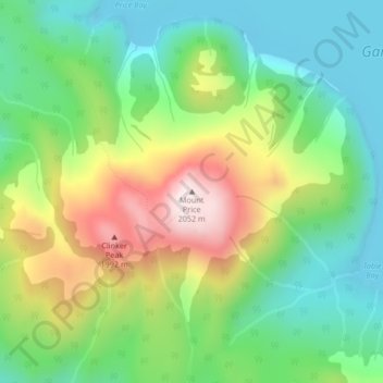
Name: Mount Price topographic map, elevation, terrain.
Average elevation: 5,486 ft
Minimum elevation: 4,793 ft
Maximum elevation: 6,690 ft
Other topographic maps
Click on a map to view its topography, its elevation and its terrain.
Daisy Lake
Canada > British Columbia > Squamish-Lillooet Regional District > Area D (Elaho/Garibaldi)
Average elevation: 2,037 ft
Garibaldi Lake
Canada > British Columbia > Squamish-Lillooet Regional District > Area D (Elaho/Garibaldi)
All recreational activities in the area are governed by the regulations of Garibaldi Provincial Park. Primary access to the lake is via the 9 km (5.6 mi) long Garibaldi Lake Trail, which gains approximately 920 m (3,020 ft) of elevation from the Rubble Creek Trailhead. There are campgrounds and day-use…
Average elevation: 5,315 ft