
Daisy Lake topographic map
Click on the map to display elevation.
About this map
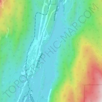
Name: Daisy Lake topographic map, elevation, terrain.
Average elevation: 2,037 ft
Minimum elevation: 1,155 ft
Maximum elevation: 4,731 ft
Other topographic maps
Click on a map to view its topography, its elevation and its terrain.
The Copilot
Canada > British Columbia > Squamish-Lillooet Regional District > Area D (Elaho/Garibaldi)
Average elevation: 4,816 ft
Mount Price
Canada > British Columbia > Squamish-Lillooet Regional District > Area D (Elaho/Garibaldi)
Mount Price is a small stratovolcano in the Garibaldi Ranges of the Pacific Ranges in southwestern British Columbia, Canada. It is located 10 km (6.2 mi) southeast of the abandoned settlement of Garibaldi above the eastern flank of the Cheakamus River valley. With a summit elevation of 2,049 m (6,722 ft), it…
Average elevation: 5,486 ft