Geolocate

Tracy topographic map

Click on the map to display elevation.

About this map

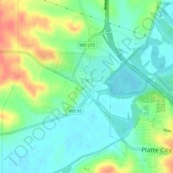
Name: Tracy topographic map, elevation, terrain.

Location: Tracy, Platte County, Missouri, United States (39.37186 -94.80003 39.38226 -94.78883)

Average elevation: 823 ft

Minimum elevation: 758 ft

Maximum elevation: 958 ft

Platte County trails, hiking, mountain biking, running and outdoor activities

Other topographic maps

Click on a map to view its topography, its elevation and its terrain.

Sadler

United States > Missouri > Platte County

Average elevation: 827 ft

Waldron

United States > Missouri > Platte County

Average elevation: 830 ft

Parkville

United States > Missouri > Platte County > Parkville > Parkville

Average elevation: 856 ft

Gear up for your next adventure:

🪶Camp Gear Gift Set - Perfect gift bundle for outdoor fans
🧯Emergency Survival Kit - All‑in‑one survival essentials for the backcountry
🌎3D Topographic Globes - Raised relief globes for a tactile understanding of geography
🛌Ultralight Sleeping Bags - Compact down bags for cold nights in the wilderness
🧥Waterproof Jacket for Hiking - Breathable and rugged rain jacket for outdoor excursions

As an Amazon Associate, this site earns from qualifying purchases at no extra cost to you.