Geolocate

上跑蹄村 topographic map

Interactive map

Click on the map to display elevation.

About this map

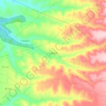
Name: 上跑蹄村 topographic map, elevation, terrain.

Location: 上跑蹄村, 洪洞县, 临汾市, 山西省, 中国 (36.42975 111.70165 36.46975 111.74165)

Average elevation: 2,218 ft

Minimum elevation: 1,749 ft

Maximum elevation: 2,644 ft

Other topographic maps

Click on a map to view its topography, its elevation and its terrain.

南庄

中国 > 山西省 > 洪洞县

南庄, 洪洞县, 临汾市, 山西省, 中国

Average elevation: 2,851 ft

师村

中国 > 山西省 > 洪洞县

师村, 洪洞县, 临汾市, 山西省, 中国

Average elevation: 2,474 ft

王家庄

中国 > 山西省 > 洪洞县

王家庄, 洪洞县, 临汾市, 山西省, 中国

Average elevation: 3,297 ft

洪洞县

中国 > 山西省 > 洪洞县

洪洞县, 临汾市, 山西省, 中国

Average elevation: 2,024 ft

洪安涧河

中国 > 山西省 > 洪洞县 > 洪洞县

洪安涧河, 洪洞县, 临汾市, 山西省, 中国

Average elevation: 1,962 ft

上桥村

中国 > 山西省 > 洪洞县

上桥村, 洪洞县, 临汾市, 山西省, 中国

Average elevation: 1,467 ft

杨曲村

中国 > 山西省 > 洪洞县

杨曲村, 洪洞县, 临汾市, 山西省, 中国

Average elevation: 1,457 ft