Geolocate

Maxwell topographic map

Click on the map to display elevation.

About this map

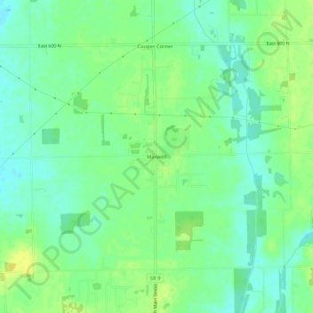
Name: Maxwell topographic map, elevation, terrain.

Location: Maxwell, Hancock County, Indiana, 46154, United States (39.83756 -85.78973 39.87756 -85.74973)

Average elevation: 906 ft

Minimum elevation: 876 ft

Maximum elevation: 938 ft

Hancock County trails, hiking, mountain biking, running and outdoor activities

Other topographic maps

Click on a map to view its topography, its elevation and its terrain.

Wilkinson

United States > Indiana > Hancock County

Average elevation: 1,007 ft

Spring Lake

United States > Indiana > Hancock County

Average elevation: 850 ft

New Palestine

United States > Indiana > Hancock County

Average elevation: 830 ft

Cumberland

United States > Indiana > Hancock County

Average elevation: 856 ft

Fortville

United States > Indiana > Hancock County

Average elevation: 863 ft

Gear up for your next adventure:

🛰️Handheld GPS Units - Professional satellite navigators for precise backcountry mapping
🎒Waterproof Dry Bags - Keep your electronics and maps dry inside your pack
🔪Outdoor Multitools - Essential survival tools for gear repair and field use
🔥Fast-Boil Camping Stoves - Efficient cooking systems for quick trail meals
📱Solar Portable Charger - Solar power bank for charging devices off‑grid

As an Amazon Associate, this site earns from qualifying purchases at no extra cost to you.