
Make a donation
Gear up for your next adventure:
As an Amazon Associate, this site earns from qualifying purchases at no extra cost to you.
Nitobe Memorial Garden topographic map
Click on the map to display elevation.
Make a donation
Gear up for your next adventure:
As an Amazon Associate, this site earns from qualifying purchases at no extra cost to you.
About this map
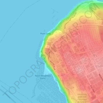
Name: Nitobe Memorial Garden topographic map, elevation, terrain.
Average elevation: 118 ft
Minimum elevation: 0 ft
Maximum elevation: 338 ft
Make a donation
Gear up for your next adventure:
As an Amazon Associate, this site earns from qualifying purchases at no extra cost to you.
Other topographic maps
Click on a map to view its topography, its elevation and its terrain.
Barnes Lake
Canada > British Columbia > Metro Vancouver Regional District > Electoral Area A
Average elevation: 4,190 ft
Wreck Beach
Canada > British Columbia > Metro Vancouver Regional District > Electoral Area A
Average elevation: 105 ft
Barnston Island
Canada > British Columbia > Metro Vancouver Regional District > Electoral Area A
Average elevation: 20 ft
Passage Island
Canada > British Columbia > Metro Vancouver Regional District > Electoral Area A
Average elevation: 0 ft
Make a donation
Gear up for your next adventure:
As an Amazon Associate, this site earns from qualifying purchases at no extra cost to you.
Mount Eldee
Canada > British Columbia > Metro Vancouver Regional District > Electoral Area A
Average elevation: 3,366 ft
Seymour River
Canada > British Columbia > Metro Vancouver Regional District > Electoral Area A
Average elevation: 1,608 ft