
Mount Eldee topographic map
Click on the map to display elevation.
About this map
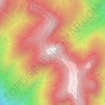
Name: Mount Eldee topographic map, elevation, terrain.
Average elevation: 3,366 ft
Minimum elevation: 942 ft
Maximum elevation: 4,619 ft
Other topographic maps
Click on a map to view its topography, its elevation and its terrain.
Lower Seymour Conservation Reserve
Canada > British Columbia > Metro Vancouver Regional District > Electoral Area A
Average elevation: 1,985 ft
Pitt Lake
Canada > British Columbia > Metro Vancouver Regional District > Electoral Area A
Average elevation: 2,162 ft
Barnes Lake
Canada > British Columbia > Metro Vancouver Regional District > Electoral Area A
Average elevation: 4,190 ft
Wreck Beach
Canada > British Columbia > Metro Vancouver Regional District > Electoral Area A
Average elevation: 105 ft
Tower Beach
Canada > British Columbia > Metro Vancouver Regional District > Electoral Area A
Average elevation: 89 ft
Indian Arm
Canada > British Columbia > Metro Vancouver Regional District > Electoral Area A
Average elevation: 1,519 ft
Capilano River
Canada > British Columbia > Metro Vancouver Regional District > Electoral Area A
Average elevation: 1,955 ft
Barnston Island
Canada > British Columbia > Metro Vancouver Regional District > Electoral Area A
Average elevation: 20 ft
Pacific Spirit Regional Park
Canada > British Columbia > Metro Vancouver Regional District > Electoral Area A
Average elevation: 184 ft
University of British Columbia
Canada > British Columbia > Metro Vancouver Regional District > Electoral Area A
Average elevation: 187 ft
Passage Island
Canada > British Columbia > Metro Vancouver Regional District > Electoral Area A
Average elevation: 0 ft
Nitobe Memorial Garden
Canada > British Columbia > Metro Vancouver Regional District > Electoral Area A
Average elevation: 118 ft
Seymour River
Canada > British Columbia > Metro Vancouver Regional District > Electoral Area A
Average elevation: 1,608 ft
University of British Columbia
Canada > British Columbia > Metro Vancouver Regional District > Electoral Area A
Average elevation: 210 ft