Geolocate

Lentag topographic map

Click on the map to display elevation.

About this map

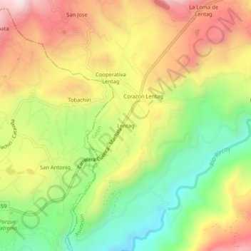
Name: Lentag topographic map, elevation, terrain.

Location: Lentag, Asuncion, Girón, Azuay, Ecuador (-3.27377 -79.25898 -3.23377 -79.21898)

Average elevation: 4,931 ft

Minimum elevation: 3,868 ft

Maximum elevation: 6,056 ft

Other topographic maps

Click on a map to view its topography, its elevation and its terrain.

Giron

Ecuador > Azuay > Girón

The town of Girón is located 44 km southwest of Cuenca by road, at an elevation of 2160 m.

Average elevation: 9,432 ft

Gear up for your next adventure:

Camping Coffee Makers - Enjoy premium coffee at the summit or campsite
🌎3D Topographic Globes - Raised relief globes for a tactile understanding of geography
🧴Hand Sanitizer - Keep hands clean while hiking
📡GPS Antenna Upgrade - Enhance GPS reception in remote terrain
🖼️Topo Map Wall Art - Decorative topographic prints of famous peaks and regions

As an Amazon Associate, this site earns from qualifying purchases at no extra cost to you.