
Make a donation
Gear up for your next adventure:
As an Amazon Associate, this site earns from qualifying purchases at no extra cost to you.
Rogers Island topographic map
Click on the map to display elevation.
Make a donation
Gear up for your next adventure:
As an Amazon Associate, this site earns from qualifying purchases at no extra cost to you.
About this map
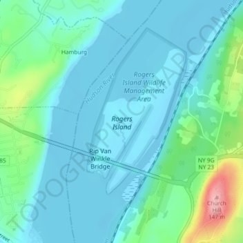
Name: Rogers Island topographic map, elevation, terrain.
Average elevation: 85 ft
Minimum elevation: -23 ft
Maximum elevation: 469 ft
Columbia County trails, hiking, mountain biking, running and outdoor activities
Make a donation
Gear up for your next adventure:
As an Amazon Associate, this site earns from qualifying purchases at no extra cost to you.
Other topographic maps
Click on a map to view its topography, its elevation and its terrain.
Nutten Hook State Tidal Wetland
United States > New York > Columbia County > Town of Stuyvesant
Average elevation: 105 ft
Make a donation
Gear up for your next adventure:
As an Amazon Associate, this site earns from qualifying purchases at no extra cost to you.
Make a donation
Gear up for your next adventure:
As an Amazon Associate, this site earns from qualifying purchases at no extra cost to you.
Olana State Historic Site
United States > New York > Columbia County > Greendale
Average elevation: 171 ft
Copake Lake
United States > New York > Columbia County > Town of Copake > Copake Lake
Average elevation: 771 ft
Make a donation
Gear up for your next adventure:
As an Amazon Associate, this site earns from qualifying purchases at no extra cost to you.
Make a donation
Gear up for your next adventure:
As an Amazon Associate, this site earns from qualifying purchases at no extra cost to you.
Make a donation
Gear up for your next adventure:
As an Amazon Associate, this site earns from qualifying purchases at no extra cost to you.
Make a donation
Gear up for your next adventure:
As an Amazon Associate, this site earns from qualifying purchases at no extra cost to you.
Make a donation
Gear up for your next adventure:
As an Amazon Associate, this site earns from qualifying purchases at no extra cost to you.
Upper Hollowville
United States > New York > Columbia County > Town of Claverack
Average elevation: 623 ft
Make a donation
Gear up for your next adventure:
As an Amazon Associate, this site earns from qualifying purchases at no extra cost to you.
Make a donation
Gear up for your next adventure:
As an Amazon Associate, this site earns from qualifying purchases at no extra cost to you.
Make a donation
Gear up for your next adventure:
As an Amazon Associate, this site earns from qualifying purchases at no extra cost to you.
Make a donation
Gear up for your next adventure:
As an Amazon Associate, this site earns from qualifying purchases at no extra cost to you.
North Hillsdale
United States > New York > Columbia County > Town of Hillsdale
Average elevation: 1,010 ft
Make a donation
Gear up for your next adventure:
As an Amazon Associate, this site earns from qualifying purchases at no extra cost to you.
Valatie Colony
United States > New York > Columbia County > Town of Kinderhook
Average elevation: 308 ft
Make a donation
Gear up for your next adventure:
As an Amazon Associate, this site earns from qualifying purchases at no extra cost to you.
Linlithgo Mills
United States > New York > Columbia County > Town of Livingston
Average elevation: 249 ft
Lebanon Springs
United States > New York > Columbia County > Town of New Lebanon
Average elevation: 1,030 ft
New Britain
United States > New York > Columbia County > Town of New Lebanon
Average elevation: 1,020 ft
Make a donation
Gear up for your next adventure:
As an Amazon Associate, this site earns from qualifying purchases at no extra cost to you.
New Lebanon Center
United States > New York > Columbia County > Town of New Lebanon
Average elevation: 932 ft
West Lebanon
United States > New York > Columbia County > Town of New Lebanon
Average elevation: 797 ft
Make a donation
Gear up for your next adventure:
As an Amazon Associate, this site earns from qualifying purchases at no extra cost to you.
East Taghkanic
United States > New York > Columbia County > Town of Taghkanic
Average elevation: 656 ft
Make a donation
Gear up for your next adventure:
As an Amazon Associate, this site earns from qualifying purchases at no extra cost to you.
West Taghkanic
United States > New York > Columbia County > Town of Taghkanic
Average elevation: 482 ft
Stuyvesant Falls
United States > New York > Columbia County > Town of Stuyvesant
Average elevation: 190 ft
Green River
United States > New York > Columbia County > Town of Hillsdale
Average elevation: 1,253 ft
Make a donation
Gear up for your next adventure:
As an Amazon Associate, this site earns from qualifying purchases at no extra cost to you.
Make a donation
Gear up for your next adventure:
As an Amazon Associate, this site earns from qualifying purchases at no extra cost to you.
Columbiaville
United States > New York > Columbia County > Town of Stockport
Average elevation: 105 ft
Make a donation
Gear up for your next adventure:
As an Amazon Associate, this site earns from qualifying purchases at no extra cost to you.