Geolocate

Avonia topographic map

Click on the map to display elevation.

About this map

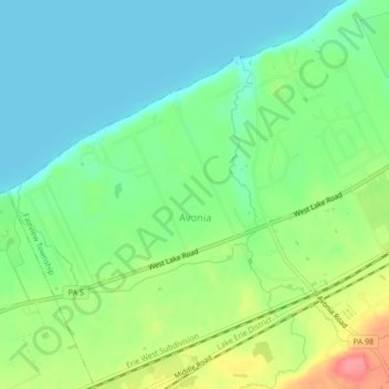
Name: Avonia topographic map, elevation, terrain.

Location: Avonia, Erie County, Pennsylvania, United States (42.03198 -80.29870 42.06378 -80.25624)

Average elevation: 656 ft

Minimum elevation: 564 ft

Maximum elevation: 843 ft

Erie County trails, hiking, mountain biking, running and outdoor activities

Other topographic maps

Click on a map to view its topography, its elevation and its terrain.

Little Hope

United States > Pennsylvania > Erie County

Average elevation: 1,421 ft

Erie

United States > Pennsylvania > Erie County > Erie

Average elevation: 833 ft

Jackson

United States > Pennsylvania > Erie County > Jackson

Average elevation: 1,306 ft

Belleview Heights

United States > Pennsylvania > Erie County

Average elevation: 1,171 ft

Gear up for your next adventure:

🧭Pro Hiking Compasses - High-accuracy liquid-filled compasses for topographic orientation
🎒Day Hiking Backpack - Lightweight backpack perfect for day trips and outdoor adventures
🧷Carabiner Set - Durable clips for gear attachment
🏫Relief Map Kits - Hands-on tools for teaching landforms and elevation
🧭Orienteering Set - Complete compass and map reading kit

As an Amazon Associate, this site earns from qualifying purchases at no extra cost to you.