Geolocate

Kibler topographic map

Click on the map to display elevation.

About this map

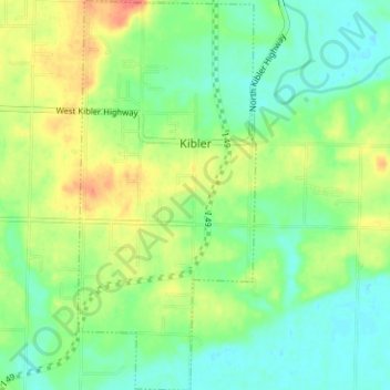
Name: Kibler topographic map, elevation, terrain.

Location: Kibler, Crawford County, Arkansas, United States (35.39780 -94.25066 35.44912 -94.21364)

Average elevation: 440 ft

Minimum elevation: 377 ft

Maximum elevation: 531 ft

Crawford County trails, hiking, mountain biking, running and outdoor activities

Other topographic maps

Click on a map to view its topography, its elevation and its terrain.

Artist Point

United States > Arkansas > Crawford County

Average elevation: 1,467 ft

Barcelona

United States > Arkansas > Crawford County

Average elevation: 774 ft

Uniontown

United States > Arkansas > Crawford County

Average elevation: 850 ft

Dora

United States > Arkansas > Crawford County

Average elevation: 531 ft

Alma

United States > Arkansas > Crawford County

Average elevation: 554 ft

Lee Creek

United States > Arkansas > Crawford County

Average elevation: 928 ft

Dyer

United States > Arkansas > Crawford County

Average elevation: 459 ft

Gear up for your next adventure:

🏫Relief Map Kits - Hands-on tools for teaching landforms and elevation
🧣Merino Neck Gaiters - Multi-functional headwear for wind and sun protection
👟Trail Running Shoes - Lightweight shoes for trail runners
🔥Camping Stove - Portable stove for camping and backcountry cooking
📱Heavy-Duty Phone Cases - Drop-proof and waterproof protection for outdoor navigation

As an Amazon Associate, this site earns from qualifying purchases at no extra cost to you.