
Make a donation
Gear up for your next adventure:
As an Amazon Associate, this site earns from qualifying purchases at no extra cost to you.
Surry topographic map
Click on the map to display elevation.
Make a donation
Gear up for your next adventure:
As an Amazon Associate, this site earns from qualifying purchases at no extra cost to you.
Surry
According to the United States Census Bureau, the town has a total area of 16.0 square miles (41.4 km2), of which 15.7 square miles (40.6 km2) are land and 0.31 square miles (0.8 km2) is water, comprising 1.97% of the town. The highest point in Surry is along the town's western border, on the upper slopes of Derry Hill, where the elevation reaches 1,555 feet (474 m).
Make a donation
Gear up for your next adventure:
As an Amazon Associate, this site earns from qualifying purchases at no extra cost to you.
About this map
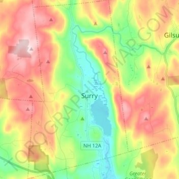
Name: Surry topographic map, elevation, terrain.
Location: Surry, Cheshire County, New Hampshire, United States (42.97653 -72.36324 43.06534 -72.29501)
Average elevation: 1,014 ft
Minimum elevation: 472 ft
Maximum elevation: 1,654 ft
Cheshire County trails, hiking, mountain biking, running and outdoor activities
Make a donation
Gear up for your next adventure:
As an Amazon Associate, this site earns from qualifying purchases at no extra cost to you.
Other topographic maps
Click on a map to view its topography, its elevation and its terrain.
West Chesterfield
United States > New Hampshire > Cheshire County > Chesterfield
Average elevation: 551 ft
Camp Notre Dame
United States > New Hampshire > Cheshire County > Chesterfield
Average elevation: 732 ft
Make a donation
Gear up for your next adventure:
As an Amazon Associate, this site earns from qualifying purchases at no extra cost to you.
Make a donation
Gear up for your next adventure:
As an Amazon Associate, this site earns from qualifying purchases at no extra cost to you.
Make a donation
Gear up for your next adventure:
As an Amazon Associate, this site earns from qualifying purchases at no extra cost to you.
Scotland
United States > New Hampshire > Cheshire County > Winchester > Scotland
Average elevation: 686 ft
Alstead Center
United States > New Hampshire > Cheshire County > Alstead > Alstead Center
Average elevation: 1,217 ft
Make a donation
Gear up for your next adventure:
As an Amazon Associate, this site earns from qualifying purchases at no extra cost to you.
Longmeadow Subdivision
United States > New Hampshire > Cheshire County > Keene
Average elevation: 587 ft