
Reynolds Mountain topographic map
Interactive map
Click on the map to display elevation.
About this map
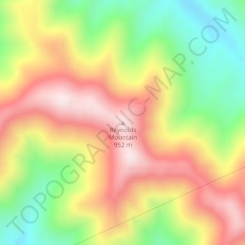
Name: Reynolds Mountain topographic map, elevation, terrain.
Location: Reynolds Mountain, Harlan County, Kentucky, 40863, USA (36.78393 -83.46746 36.78403 -83.46736)
Average elevation: 2,247 ft
Minimum elevation: 1,355 ft
Maximum elevation: 3,100 ft
Other topographic maps
Click on a map to view its topography, its elevation and its terrain.
Daniel Boone National Forest
Daniel Boone National Forest, Forest Road, Lakes, Jackson County, Kentucky, USA
Average elevation: 1,119 ft
Herrington Lake
USA > Kentucky > Little Needmore
Herrington Lake, Taylor Road, Little Needmore, Boyle County, Kentucky, USA
Average elevation: 856 ft
Floyds Fork
USA > Kentucky > Louisville
Floyds Fork, Louisville, Jefferson County, Kentucky, 40023, USA
Average elevation: 627 ft
Grayson Lake
Grayson Lake, Horton Flats Road, Bruin, Elliott County, Kentucky, USA
Average elevation: 863 ft
Fishtrap Lake
Fishtrap Lake, Island Creek Road, Phyllis, Pike County, Kentucky, 41554, USA
Average elevation: 1,319 ft
Raven Run Nature Sanctuary
Raven Run Nature Sanctuary, Lexington, Fayette County, Kentucky, USA
Average elevation: 873 ft
Powder Mill
USA > Kentucky > Powder Mill
Powder Mill, Hart County, Kentucky, USA
Average elevation: 669 ft
Basil Lewis Park
Basil Lewis Park, Latonia, Covington, Kenton County, Kentucky, USA
Average elevation: 535 ft
Stringtown
USA > Kentucky > Stringtown
Stringtown, Boone County, Kentucky, 45233, USA
Average elevation: 705 ft
Johnsonville
USA > Kentucky > Johnsonville
Johnsonville, Anderson County, Kentucky, USA
Average elevation: 748 ft
Henry Mountain
Henry Mountain, Estill County, Kentucky, 40336, USA
Average elevation: 787 ft
Abraham Lincoln Birthplace National Historic Site
USA > Kentucky > Boundary Oak
Abraham Lincoln Birthplace National Historic Site, Boundary Oak, Larue County, Kentucky, USA
Average elevation: 781 ft
Coxs Creek
USA > Kentucky > Coxs Creek
Coxs Creek, Nelson County, Kentucky, 40013, USA
Average elevation: 646 ft
Falling Branch
USA > Kentucky > Falling Branch
Falling Branch, Grayson County, Kentucky, 40119, USA
Average elevation: 561 ft
Harrods Creek
USA > Kentucky > Harrods Creek
Harrods Creek, Jefferson County, Kentucky, 40059, USA
Average elevation: 505 ft
Edwards Mountain
Edwards Mountain, Wayne County, Kentucky, USA
Average elevation: 1,398 ft
Cumberland Island
Cumberland Island, Livingston County, Kentucky, USA
Average elevation: 328 ft
William Whitley House State Shrine
USA > Kentucky > Sugar Grove
William Whitley House State Shrine, Sugar Grove, Lincoln County, Kentucky, USA
Average elevation: 932 ft
General James Taylor Park
General James Taylor Park, Newport, Campbell County, Kentucky, USA
Average elevation: 518 ft
Beargrass Creek
USA > Kentucky > Louisville
Beargrass Creek, Louisville, Jefferson County, Kentucky, USA
Average elevation: 469 ft
Society Hill
Society Hill, Metcalfe County, Kentucky, 42129, USA
Average elevation: 938 ft
Mount Morgan
Mount Morgan, Whitley County, Kentucky, 40769, USA
Average elevation: 1,227 ft
Green River Lake
Green River Lake, Hayes Lane, Atchison, Taylor County, Kentucky, USA
Average elevation: 794 ft
White Pine Hollow
White Pine Hollow, Rowan County, Kentucky, USA
Average elevation: 1,063 ft
Kentucky Horse Park
USA > Kentucky > Spindletop Estates
Kentucky Horse Park, Spindletop Estates, Fayette County, Kentucky, USA
Average elevation: 902 ft
Kincaid Lake
Kincaid Lake, Buckeye Hills Road, Concord, Pendleton County, Kentucky, USA
Average elevation: 709 ft