
Carlin topographic map
Interactive map
Click on the map to display elevation.
Carlin
Carlin is a small city located near the western border of Elko County in northeast Nevada, 23 miles (37 km) west of the city of Elko. It is part of the Elko Micropolitan Statistical Area. Carlin sits along Interstate 80 at an elevation of approximately 4,900 feet (1,500 m). As of the 2010 census, its population was 2,368,[3] up from 2,161 at the 2000 census. The city was named for Civil War general William Passmore Carlin.[4] Its slogan is "Where the Train Stops...And the Gold Rush Begins".[1]
About this map
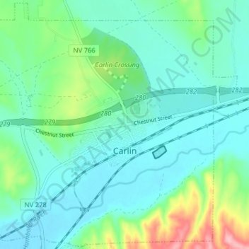
Name: Carlin topographic map, elevation, terrain.
Location: Carlin, Elko County, Nevada, 89822, United States (40.69421 -116.14234 40.74197 -116.07805)
Average elevation: 4,993 ft
Minimum elevation: 4,879 ft
Maximum elevation: 5,381 ft
Elko County trails, hiking, mountain biking, running and outdoor activities
Other topographic maps
Click on a map to view its topography, its elevation and its terrain.
Zunino Reservoir Dam;Zunino Reservoir
United States > Nevada > Elko County
Average elevation: 5,620 ft
Ruby Mountains
United States > Nevada > Elko County
The Ruby Mountains (Shoshoni: 'Duka Doya', meaning “Snowcapped”) are a mountain range, primarily located within Elko County with a small extension into White Pine County, in Nevada, United States. Most of the range is included within the Humboldt-Toiyabe National Forest. The range reaches a maximum…
Average elevation: 6,437 ft
Angel Lake
United States > Nevada > Elko County
Angel Lake is a glacial tarn in the northern part of the East Humboldt Range, in central Elko County in the northeastern part of the state of Nevada. It is located at approximately 41°01.6′N 115°05.1′W / 41.0267°N 115.0850°W / 41.0267; -115.0850, and at an elevation of 8378 feet (2553 m). It…
Average elevation: 8,766 ft