
Brighton topographic map
Click on the map to display elevation.
About this map
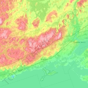
Name: Brighton topographic map, elevation, terrain.
Average elevation: 423 ft
Minimum elevation: 157 ft
Maximum elevation: 860 ft
Other topographic maps
Click on a map to view its topography, its elevation and its terrain.
Grafton
Canada > Ontario > Northumberland County > Alnwick/Haldimand > Grafton
Average elevation: 407 ft
Presqu'ile Provincial Park
Canada > Ontario > Northumberland County > Brighton
Average elevation: 249 ft
Camborne
Canada > Ontario > Northumberland County > Hamilton Township > Camborne
Average elevation: 643 ft