
Harper topographic map
Click on the map to display elevation.
About this map
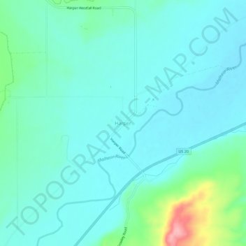
Name: Harper topographic map, elevation, terrain.
Location: Harper, Malheur County, Oregon, 97906, United States (43.84321 -117.62991 43.88321 -117.58991)
Average elevation: 2,562 ft
Minimum elevation: 2,484 ft
Maximum elevation: 2,920 ft
Malheur County trails, hiking, mountain biking, running and outdoor activities
Other topographic maps
Click on a map to view its topography, its elevation and its terrain.
Vale
United States > Oregon > Malheur County
According to the United States Census Bureau, the city has a total area of 1.14 square miles (2.95 km2), all of it land. The city has an elevation of 2,244 feet (684 m) above sea level.
Average elevation: 2,329 ft