Geolocate

Berryville topographic map

Click on the map to display elevation.

About this map

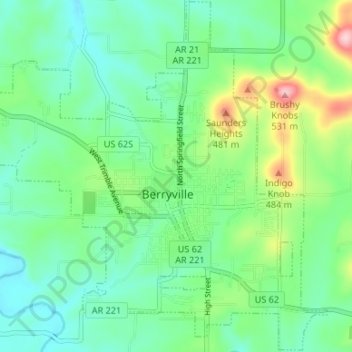
Name: Berryville topographic map, elevation, terrain.

Location: Berryville, Carroll County, Arkansas, 72616, United States (36.34665 -93.60588 36.39976 -93.53482)

Average elevation: 1,234 ft

Minimum elevation: 1,050 ft

Maximum elevation: 1,739 ft

Carroll County trails, hiking, mountain biking, running and outdoor activities

Other topographic maps

Click on a map to view its topography, its elevation and its terrain.

Inspiration Point

United States > Arkansas > Carroll County

Average elevation: 1,250 ft

Delmar

United States > Arkansas > Carroll County

Average elevation: 1,755 ft

Osage

United States > Arkansas > Carroll County

Average elevation: 1,526 ft

Holiday Island

United States > Arkansas > Carroll County

Average elevation: 1,188 ft

Eureka Springs

United States > Arkansas > Carroll County > Eureka Springs

It is a tourist destination for its unique character as a Victorian resort village. The city has steep winding streets filled with Victorian-style cottages and manors. The historic commercial downtown of the city has an extensive streetscape of well-preserved Victorian buildings. The buildings are primarily…

Average elevation: 1,368 ft

Gear up for your next adventure:

🚗GPS Dash Cams - Record your scenic drives through mountain passes and canyons
🧦Hiking Socks - Comfortable socks to prevent blisters on long hikes
📱Heavy-Duty Phone Cases - Drop-proof and waterproof protection for outdoor navigation
🥩Freeze-Dried Meals - Nutritious and lightweight food for remote expeditions
⛑️Personal Locator Beacon - Safety beacon for emergencies

As an Amazon Associate, this site earns from qualifying purchases at no extra cost to you.