
Make a donation
Gear up for your next adventure:
As an Amazon Associate, this site earns from qualifying purchases at no extra cost to you.
Lansford topographic map
Click on the map to display elevation.
Make a donation
Gear up for your next adventure:
As an Amazon Associate, this site earns from qualifying purchases at no extra cost to you.
Lansford
According to the United States Census Bureau, the borough has a total area of 1.6 square miles (4.1 km2), all of it land. The town shares the border of Carbon and Schuylkill County with the abutting neighboring community of Coaldale, which is de facto, a suburban bedroom neighborhood. Lansford is 1 mile north of Summit Hill (where the first anthracite deposits mined by the Lehigh Coal Company were discovered in the 1780s); 10 miles west of Lehighton, and 6 miles northeast of Tamaqua. Lansford's elevation is 1145 feet above sea level. It is also 27 miles northwest of Allentown and 9 miles south of Hazleton. It is located on the northwestern fringe of the Lehigh Valley and is at the southern end of the Coal Region and the Pocono Mountains.
Make a donation
Gear up for your next adventure:
As an Amazon Associate, this site earns from qualifying purchases at no extra cost to you.
About this map
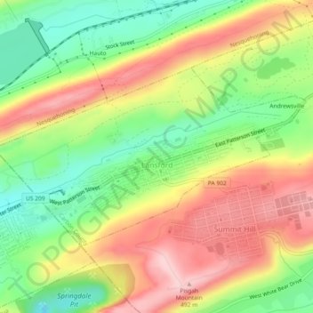
Name: Lansford topographic map, elevation, terrain.
Location: Lansford, Carbon County, Pennsylvania, 18232, United States (40.82292 -75.90624 40.84262 -75.86052)
Average elevation: 1,247 ft
Minimum elevation: 909 ft
Maximum elevation: 1,601 ft
Carbon County trails, hiking, mountain biking, running and outdoor activities
Make a donation
Gear up for your next adventure:
As an Amazon Associate, this site earns from qualifying purchases at no extra cost to you.
Other topographic maps
Click on a map to view its topography, its elevation and its terrain.
Beltzville Lake
United States > Pennsylvania > Carbon County > Towamensing Township
Average elevation: 886 ft
Leonardsville
United States > Pennsylvania > Carbon County > Kidder Township
Average elevation: 1,660 ft
White Bear Creek
United States > Pennsylvania > Carbon County > Summit Hill
Average elevation: 1,332 ft
Pisgah Mountain
United States > Pennsylvania > Carbon County > Summit Hill
Average elevation: 1,322 ft
Make a donation
Gear up for your next adventure:
As an Amazon Associate, this site earns from qualifying purchases at no extra cost to you.
Lake Harmony
United States > Pennsylvania > Carbon County > Kidder Township
Average elevation: 1,808 ft
Make a donation
Gear up for your next adventure:
As an Amazon Associate, this site earns from qualifying purchases at no extra cost to you.
Pleasant Corners
United States > Pennsylvania > Carbon County > Mahoning Township
Average elevation: 732 ft
Christian Corner
United States > Pennsylvania > Carbon County > Lower Towamensing Township
Average elevation: 741 ft
East Jim Thorpe
United States > Pennsylvania > Carbon County > Jim Thorpe > East Jim Thorpe
Average elevation: 892 ft