Geolocate

阿旺乡 topographic map

Interactive map

Click on the map to display elevation.

About this map

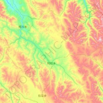
Name: 阿旺乡 topographic map, elevation, terrain.

Location: 阿旺乡, 贡觉县, 昌都市, 西藏自治区, 中国 (30.38056 98.43835 30.80256 98.81729)

Average elevation: 14,354 ft

Minimum elevation: 11,965 ft

Maximum elevation: 17,644 ft

Other topographic maps

Click on a map to view its topography, its elevation and its terrain.

相皮乡

中国 > 西藏自治区 > 贡觉县

相皮乡, 贡觉县, 昌都市, 西藏自治区, 中国

Average elevation: 13,944 ft

莫洛镇

中国 > 西藏自治区 > 贡觉县

莫洛镇, 贡觉县, 昌都市, 西藏自治区, 中国

Average elevation: 13,914 ft

罗麦乡

中国 > 西藏自治区 > 贡觉县

罗麦乡, 贡觉县, 昌都市, 西藏自治区, 中国

Average elevation: 13,212 ft

则巴乡

中国 > 西藏自治区 > 贡觉县

则巴乡, 贡觉县, 昌都市, 西藏自治区, 中国

Average elevation: 13,953 ft

沙东乡

中国 > 西藏自治区 > 贡觉县

沙东乡, 贡觉县, 昌都市, 西藏自治区, 中国

Average elevation: 12,726 ft

哈加乡

中国 > 西藏自治区 > 贡觉县

哈加乡, 贡觉县, 昌都市, 西藏自治区, 中国

Average elevation: 13,819 ft