Geolocate

Dargaz County topographic map

Click on the map to display elevation.

About this map

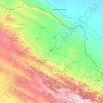
Name: Dargaz County topographic map, elevation, terrain.

Location: Dargaz County, Razavi Khorasan, 94917-39431, Iran (36.97024 58.47688 37.70583 59.43189)

Average elevation: 3,704 ft

Minimum elevation: 535 ft

Maximum elevation: 10,190 ft

Other topographic maps

Click on a map to view its topography, its elevation and its terrain.

Al

Iran > Razavi Khorasan > Mashhad County > دهستان کارده

Average elevation: 5,541 ft

Fariman

Iran > Razavi Khorasan > Fariman County > Fariman

Average elevation: 4,623 ft

Kalat

Iran > Razavi Khorasan > Gonabad County > دهستان زیبد

Average elevation: 5,367 ft

Hassanabad

Iran > Razavi Khorasan > Khaf County

Average elevation: 2,372 ft

Khargerd

Iran > Razavi Khorasan > Khaf County

Average elevation: 3,156 ft

Gear up for your next adventure:

🧤Hiking Gloves - Protective gloves for rugged trails
🪶LED Camping Lantern - Bright lantern for camp lighting
👖Convertible Hiking Pants - Versatile zip-off pants for changing altitudes and temperatures
🧣Hiking Neck Gaiter - Multi‑use neck protection for outdoor weather
🔭Compact Binoculars - HD vision for scouting terrain and identifying distant landmarks

As an Amazon Associate, this site earns from qualifying purchases at no extra cost to you.