Geolocate

Mendon topographic map

Click on the map to display elevation.

About this map

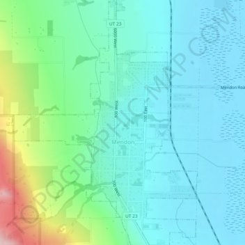
Name: Mendon topographic map, elevation, terrain.

Location: Mendon, Cache County, Utah, United States (41.69538 -111.99962 41.72985 -111.96369)

Average elevation: 4,590 ft

Minimum elevation: 4,406 ft

Maximum elevation: 5,272 ft

Cache County trails, hiking, mountain biking, running and outdoor activities

Other topographic maps

Click on a map to view its topography, its elevation and its terrain.

Hyrum

United States > Utah > Cache County > Hyrum > Hyrum

Average elevation: 4,721 ft

Greenville

United States > Utah > Cache County > North Logan

Average elevation: 4,557 ft

Mount Pisgah

United States > Utah > Cache County

Average elevation: 6,109 ft

Bald Head

United States > Utah > Cache County

Average elevation: 6,378 ft

Providence Canyon

United States > Utah > Cache County

Average elevation: 6,001 ft

Logan

United States > Utah > Cache County > Logan > Logan

Average elevation: 4,656 ft

Gear up for your next adventure:

🧺Microfiber Travel Towels - Compact and fast-drying towels for trail use
🥇GPS Hiking Watch - Multi‑sport GPS watch with navigation and trail tracking
🧣Hiking Neck Gaiter - Multi‑use neck protection for outdoor weather
🪓Survival Multi‑Tool - Versatile tool for camp and trail tasks
🥄Camping Utensil Set - Lightweight utensils for outdoor meals

As an Amazon Associate, this site earns from qualifying purchases at no extra cost to you.