
Make a donation
Gear up for your next adventure:
As an Amazon Associate, this site earns from qualifying purchases at no extra cost to you.
Fazil topographic map
Click on the map to display elevation.
Make a donation
Gear up for your next adventure:
As an Amazon Associate, this site earns from qualifying purchases at no extra cost to you.
About this map
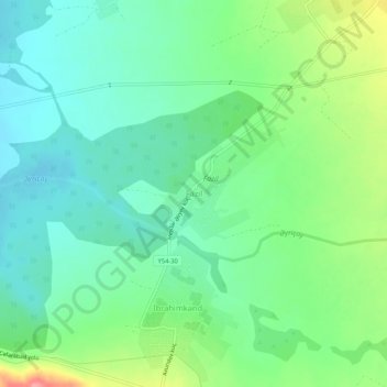
Name: Fazil topographic map, elevation, terrain.
Location: Fazil, Sheki District, Azerbaijan (41.01359 47.20924 41.05359 47.24924)
Average elevation: 1,266 ft
Minimum elevation: 1,168 ft
Maximum elevation: 1,493 ft
Make a donation
Gear up for your next adventure:
As an Amazon Associate, this site earns from qualifying purchases at no extra cost to you.
Other topographic maps
Click on a map to view its topography, its elevation and its terrain.
Ismailli District
The landscape is mainly composed of mountains. Altitudes vary between 200 and 3629 meters (Babadagh) above sea level. The area is passed by the Goychay, Gyrdyman, Akhokh, Ayrichay, Sulut and other rivers, Yekekhana and Ashygbayram artificial ponds.
Average elevation: 3,310 ft
Make a donation
Gear up for your next adventure:
As an Amazon Associate, this site earns from qualifying purchases at no extra cost to you.
Quba-Khachmaz
The climate of the region has special topographic characteristic with four different zones. Clime types are divided into hot in the plain zones, cold-humid and cold in the mountain zones.
Average elevation: 2,123 ft
Make a donation
Gear up for your next adventure:
As an Amazon Associate, this site earns from qualifying purchases at no extra cost to you.
Jalilabad District
The territory of the district primarily consists of plains and low mountains. The elevation of the eastern part is below sea level. The climate is mild with dry summers. The average temperature is 1–3 °C (34–37 °F) in winter and 25–30 °C (77–86 °F) in summer. The average amount of annual…
Average elevation: 607 ft
Make a donation
Gear up for your next adventure:
As an Amazon Associate, this site earns from qualifying purchases at no extra cost to you.
Make a donation
Gear up for your next adventure:
As an Amazon Associate, this site earns from qualifying purchases at no extra cost to you.
Nakhchivan
Azerbaijan > Nakhchivan Autonomous Republic
Nakhchivan (Azerbaijani: Naxçıvan Azerbaijani pronunciation: [nɑxtʃɯˈvɑn]; Armenian: Նախիջևան, romanized: Nakhijevan) is the capital and largest city of the eponymous Nakhchivan Autonomous Republic, a true exclave of Azerbaijan, located 450 km (280 mi) west of Baku. The municipality of…
Average elevation: 2,907 ft
Khankendi
Stepanakert is located on the Karabakh plateau, at an average altitude of 813 m (2,667 ft) above sea level.
Average elevation: 2,900 ft
Make a donation
Gear up for your next adventure:
As an Amazon Associate, this site earns from qualifying purchases at no extra cost to you.
Make a donation
Gear up for your next adventure:
As an Amazon Associate, this site earns from qualifying purchases at no extra cost to you.
Naftalan City
Naftalan city is located 330 km west of Baku, 50 km from Ganja in the foothills of the Lesser Caucasus Mountains. It's located at an altitude of 225 m above sea level. The spring is warm, the winter is soft here. The average annual temperature is +14.8 degrees. The wind in Naftalan is mainly monsoon. The…
Average elevation: 794 ft
Make a donation
Gear up for your next adventure:
As an Amazon Associate, this site earns from qualifying purchases at no extra cost to you.
Make a donation
Gear up for your next adventure:
As an Amazon Associate, this site earns from qualifying purchases at no extra cost to you.
Make a donation
Gear up for your next adventure:
As an Amazon Associate, this site earns from qualifying purchases at no extra cost to you.
Make a donation
Gear up for your next adventure:
As an Amazon Associate, this site earns from qualifying purchases at no extra cost to you.
Make a donation
Gear up for your next adventure:
As an Amazon Associate, this site earns from qualifying purchases at no extra cost to you.
Make a donation
Gear up for your next adventure:
As an Amazon Associate, this site earns from qualifying purchases at no extra cost to you.
Make a donation
Gear up for your next adventure:
As an Amazon Associate, this site earns from qualifying purchases at no extra cost to you.
Sheki District
The elevation of 500–850 m above sea level, the mountain woodlands encompassing it prevents the city from overheating. The city is secured from floods by mountain woodlands. The mountainous grassland, brown mountain woodlands, meadow-forest, grey-brown soils cover the city. Oak, peanuts, hornbeam trees are…
Average elevation: 2,418 ft
Make a donation
Gear up for your next adventure:
As an Amazon Associate, this site earns from qualifying purchases at no extra cost to you.
Gazakh
Gazakh region is located in the western part of the republic, in the western part of the vast Ganja-Gazakh plain, which starts from the slopes of the mountain range of the Lesser Caucasus and extends along the right bank of the Kura river. The highest elevation is "Odun" mountain (1316 meters). Its nature is…
Average elevation: 1,234 ft
Khojaly District
Khojaly district is located in Nagorno-Karabakh. The territory of the district is mountainous. The highest altitudes are Qirkhqiz and Gizgala, the main rivers are Gargar and Badara. The climate is mild-hot except the mountainous area.
Average elevation: 4,386 ft
Make a donation
Gear up for your next adventure:
As an Amazon Associate, this site earns from qualifying purchases at no extra cost to you.
Make a donation
Gear up for your next adventure:
As an Amazon Associate, this site earns from qualifying purchases at no extra cost to you.
Gadabay
Gadabay lies at the northern foot of the Shahdagh Range, at an altitude of 1460 meters, on the coast of the Mis River. The city is located in the middle and high mountainous areas of the Lesser Caucasus (also called Little Caucasus).
Average elevation: 4,934 ft
Make a donation
Gear up for your next adventure:
As an Amazon Associate, this site earns from qualifying purchases at no extra cost to you.
Make a donation
Gear up for your next adventure:
As an Amazon Associate, this site earns from qualifying purchases at no extra cost to you.
Guba
Quba (Azerbaijani pronunciation: [guba]) is a city and the administrative centre of the Quba District of Azerbaijan. The city lies on the north-eastern slopes of Shahdag mountain, at an altitude of 600 metres above sea level, on the right bank of the Kudyal river. It has a population of 47,200 (2023).
Average elevation: 2,044 ft
Siazan District
The district is located in the north-eastern part of Azerbaijan, in Samur-Davachi lowland, on the shore of the Caspian Sea near the Greater Caucasus. It is geographically located in Europe. The mountain ridge crosses the western part of the lowland extending along the Caspian Sea. Its latitude is 28 metres (92…
Average elevation: 640 ft
Make a donation
Gear up for your next adventure:
As an Amazon Associate, this site earns from qualifying purchases at no extra cost to you.
Make a donation
Gear up for your next adventure:
As an Amazon Associate, this site earns from qualifying purchases at no extra cost to you.
Make a donation
Gear up for your next adventure:
As an Amazon Associate, this site earns from qualifying purchases at no extra cost to you.
Make a donation
Gear up for your next adventure:
As an Amazon Associate, this site earns from qualifying purchases at no extra cost to you.
Make a donation
Gear up for your next adventure:
As an Amazon Associate, this site earns from qualifying purchases at no extra cost to you.
Gadabay
Gadabay lies at the northern foot of the Shahdagh Range, at an altitude of 1460 meters, on the coast of the Mis River. The city is located in the middle and high mountainous areas of the Lesser Caucasus (also called Little Caucasus).
Average elevation: 4,934 ft
Make a donation
Gear up for your next adventure:
As an Amazon Associate, this site earns from qualifying purchases at no extra cost to you.
Beylagan District
Beylagan is one of the southwestern districts of Azerbaijan and situated in the Mil valley of the Kur – Araz lowland and in the middle of the Kur and Araz rivers. Geographical coordinates are 39°45’ North latitude and 47°30’ West longitude and bordering Agchabadi, Zardab, Imishli, Fuzuli districts and…
Average elevation: 190 ft
Make a donation
Gear up for your next adventure:
As an Amazon Associate, this site earns from qualifying purchases at no extra cost to you.