Geolocate

Cameron topographic map

Click on the map to display elevation.

About this map

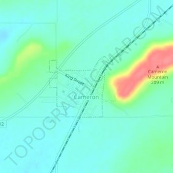
Name: Cameron topographic map, elevation, terrain.

Location: Cameron, Le Flore County, Oklahoma, United States (35.13081 -94.54183 35.14032 -94.53025)

Average elevation: 509 ft

Minimum elevation: 456 ft

Maximum elevation: 689 ft

Le Flore County trails, hiking, mountain biking, running and outdoor activities

Other topographic maps

Click on a map to view its topography, its elevation and its terrain.

Tombstone Mountain

United States > Oklahoma > Le Flore County

Average elevation: 1,496 ft

Trestle Ford

United States > Oklahoma > Le Flore County

Average elevation: 614 ft

Big Cedar

United States > Oklahoma > Le Flore County

Average elevation: 1,001 ft

Page

United States > Oklahoma > Le Flore County

Average elevation: 1,273 ft

Harvey Mountain

United States > Oklahoma > Le Flore County

Average elevation: 906 ft

Sunset Corner

United States > Oklahoma > Le Flore County

Average elevation: 482 ft

Octavia

United States > Oklahoma > Le Flore County > Octavia

Average elevation: 935 ft

Gear up for your next adventure:

📚Navigation Handbooks - Master the art of reading topographic maps and using a compass
🧤Tactile Hiking Gloves - Keep hands warm while operating GPS and smartphone screens
🥄Camping Utensil Set - Lightweight utensils for outdoor meals
Solar GPS Watches - Advanced multisport watches with built-in topographic maps
🦟Ultrasonic Repellers - Create a bug-free zone at your camp or rest stop

As an Amazon Associate, this site earns from qualifying purchases at no extra cost to you.