
Make a donation
Gear up for your next adventure:
As an Amazon Associate, this site earns from qualifying purchases at no extra cost to you.
Skokie topographic map
Click on the map to display elevation.
Make a donation
Gear up for your next adventure:
As an Amazon Associate, this site earns from qualifying purchases at no extra cost to you.
Skokie
The Chicago "L"s Yellow Line terminates at the Dempster Street station in Skokie. Construction has been completed on a new Yellow Line train station at Oakton Street, to serve downtown Skokie and environs. It opened on April 30, 2012. Additionally, the CTA is commissioning an Alternative Analysis Study on the extension of the Yellow Line terminal to Old Orchard Road for Federal Transit Administration New Start grants. The New Starts program allows federal funds to be used for capital projects provided that all solutions for a given problem (i.e., enabling easy transportation for reverse commuters to Old Orchard Mall) are considered. The solution recommended by the CTA is the elevation of the Yellow Line north of Searle Parkway to a rebuilt Dempster Street station, then following abandoned Union Pacific Railroad tracks and the east side of the Edens Expressway to a new terminal south of Old Orchard Road. Currently this solution needs to undergo public commenting as well as FTA and CTA board approval to continue.
Make a donation
Gear up for your next adventure:
As an Amazon Associate, this site earns from qualifying purchases at no extra cost to you.
About this map
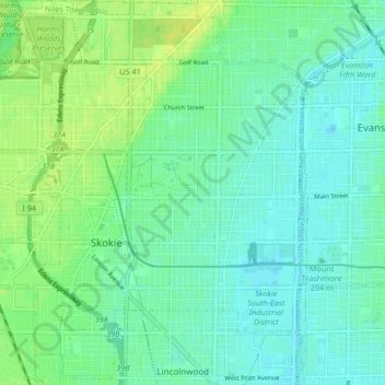
Name: Skokie topographic map, elevation, terrain.
Location: Skokie, Niles Township, Cook County, Illinois, United States (42.00455 -87.78088 42.06514 -87.70853)
Average elevation: 623 ft
Minimum elevation: 594 ft
Maximum elevation: 656 ft
Cook County trails, hiking, mountain biking, running and outdoor activities
Make a donation
Gear up for your next adventure:
As an Amazon Associate, this site earns from qualifying purchases at no extra cost to you.
Other topographic maps
Click on a map to view its topography, its elevation and its terrain.
North Pond Nature Sanctuary
United States > Illinois > Cook County > Chicago
Average elevation: 597 ft
Make a donation
Gear up for your next adventure:
As an Amazon Associate, this site earns from qualifying purchases at no extra cost to you.
Make a donation
Gear up for your next adventure:
As an Amazon Associate, this site earns from qualifying purchases at no extra cost to you.
Make a donation
Gear up for your next adventure:
As an Amazon Associate, this site earns from qualifying purchases at no extra cost to you.
Make a donation
Gear up for your next adventure:
As an Amazon Associate, this site earns from qualifying purchases at no extra cost to you.
Make a donation
Gear up for your next adventure:
As an Amazon Associate, this site earns from qualifying purchases at no extra cost to you.
Chicago, North Shore & Milwaukee
United States > Illinois > Cook County > Northbrook > Williamsburg Square
Average elevation: 650 ft
Make a donation
Gear up for your next adventure:
As an Amazon Associate, this site earns from qualifying purchases at no extra cost to you.
Elmwood Park
United States > Illinois > Cook County > Elmwood Park > Elmwood Park
Average elevation: 636 ft
Make a donation
Gear up for your next adventure:
As an Amazon Associate, this site earns from qualifying purchases at no extra cost to you.
West Branch Du Page River
United States > Illinois > Cook County > Schaumburg
Average elevation: 817 ft