Geolocate

Mahon topographic map

Click on the map to display elevation.

About this map

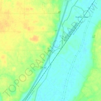
Name: Mahon topographic map, elevation, terrain.

Location: Mahon, Huntington County, Indiana, United States (40.91866 -85.40053 40.95866 -85.36053)

Average elevation: 781 ft

Minimum elevation: 738 ft

Maximum elevation: 830 ft

Other topographic maps

Click on a map to view its topography, its elevation and its terrain.

Mount Etna

United States > Indiana > Huntington County

Average elevation: 804 ft

Huntington

United States > Indiana > Huntington County

Average elevation: 781 ft

Mount Etna

United States > Indiana > Huntington County

Average elevation: 804 ft

Mount Etna

United States > Indiana > Huntington County

Average elevation: 804 ft

Mount Etna

United States > Indiana > Huntington County

Average elevation: 804 ft

Mount Etna

United States > Indiana > Huntington County

Average elevation: 804 ft

Huntington

United States > Indiana > Huntington County > Huntington

Average elevation: 781 ft

Andrews

United States > Indiana > Huntington County

Average elevation: 735 ft

Markle

United States > Indiana > Huntington County > Markle

Average elevation: 801 ft

Gear up for your next adventure:

🪶Camping Sleeping Pad - Comfortable sleeping pad for backpacking
🪶Camp Gear Gift Set - Perfect gift bundle for outdoor fans
📻Weather Alert Radios - Stay informed of storm risks while off-the-grid
🛠️Outdoor Gear Repair Kit - Essential tools to fix gear on the trail
🔋Solar Power Banks - Keep your GPS and phone charged in remote wilderness areas

As an Amazon Associate, this site earns from qualifying purchases at no extra cost to you.