
Cool Ridge topographic map
Click on the map to display elevation.
About this map
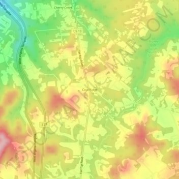
Name: Cool Ridge topographic map, elevation, terrain.
Average elevation: 2,887 ft
Minimum elevation: 2,552 ft
Maximum elevation: 3,182 ft
Raleigh County trails, hiking, mountain biking, running and outdoor activities
Other topographic maps
Click on a map to view its topography, its elevation and its terrain.
Beckley
United States > West Virginia > Raleigh County
Due to its elevation, the climate of Beckley is humid subtropical (Köppen Cfa) bordering on both an oceanic (Köppen Cfb) and humid continental (Köppen Dfa/Dfb), and the city straddles the border between USDA Plant Hardiness Zones 6B and 7A. Summers are warm and humid, usually a few degrees cooler than…
Average elevation: 2,372 ft
Shady Spring
United States > West Virginia > Raleigh County > Shady Spring
Average elevation: 2,743 ft
Crab Orchard
United States > West Virginia > Raleigh County > Crab Orchard
Average elevation: 2,415 ft
Beckley
United States > West Virginia > Raleigh County
Due to its elevation, the climate of Beckley is humid subtropical (Köppen Cfa) bordering on both an oceanic (Köppen Cfb) and humid continental (Köppen Dfa/Dfb), and the city straddles the border between USDA Plant Hardiness Zones 6B and 7A. Summers are warm and humid, usually a few degrees cooler than…
Average elevation: 2,372 ft