
Beckley topographic map
Click on the map to display elevation.
Beckley
Due to its elevation, the climate of Beckley is humid subtropical (Köppen Cfa) bordering on both an oceanic (Köppen Cfb) and humid continental (Köppen Dfa/Dfb), and the city straddles the border between USDA Plant Hardiness Zones 6B and 7A. Summers are warm and humid, usually a few degrees cooler than lower-elevation places within the state, with an average of only 1.3 days of a maximum at or above 90 °F (32 °C) annually. Winters are generally cold and snowy with occasional intervening milder periods and an average of 1.4 nights annually with a minimum of 0 °F (−18 °C) or lower. Normal monthly daily mean temperatures range from 32.2 °F (0.1 °C) in January to 71.6 °F (22.0 °C) in July. Snowfall varies with an average of 55.9 inches (142 cm) per season and mostly occurs from December to March with an occasional snowfall in November of (usually) 2–3 inches (5–8 cm). Record temperatures range from −22 °F (−30 °C) on January 21, 1985, up to 103 °F (39 °C) on July 21 and August 11, 1926; the extreme coldest daily maximum was −3 °F (−19 °C) on February 13, 1899, while, conversely, the extreme warmest daily minimum was 79 °F (26 °C) on July 7, 1924 and August 22, 1926. On average, the first and last occurrences of freezing temperatures in the cooler season are October 13 and April 30, respectively, allowing for a growing season of 165 days.
About this map
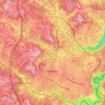
Name: Beckley topographic map, elevation, terrain.
Location: Beckley, Raleigh County, West Virginia, 25801, United States (37.75765 -81.22051 37.82144 -81.14191)
Average elevation: 2,372 ft
Minimum elevation: 1,831 ft
Maximum elevation: 2,605 ft
Raleigh County trails, hiking, mountain biking, running and outdoor activities
Other topographic maps
Click on a map to view its topography, its elevation and its terrain.
Old Mill Village
United States > West Virginia > Raleigh County > Mabscott
Average elevation: 2,421 ft
Johnstown
United States > West Virginia > Raleigh County > Beckley > Sprague
Average elevation: 2,326 ft