Geolocate

Harrington topographic map

Click on the map to display elevation.

About this map

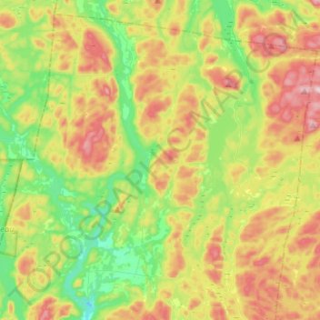
Name: Harrington topographic map, elevation, terrain.

Location: Harrington, Argenteuil, Laurentides, Quebec, Canada (45.77130 -74.75511 45.93180 -74.50320)

Average elevation: 974 ft

Minimum elevation: 463 ft

Maximum elevation: 1,722 ft

Other topographic maps

Click on a map to view its topography, its elevation and its terrain.

Lac MacLeod

Canada > Quebec > Argenteuil > Harrington

Average elevation: 951 ft

Lac Fiddler

Canada > Quebec > Argenteuil > Mille-Isles

Average elevation: 1,148 ft

Lac Bixley

Canada > Quebec > Argenteuil > Wentworth

Average elevation: 971 ft

Calumet

Canada > Quebec > Argenteuil > Grenville-sur-la-Rouge

Average elevation: 312 ft

Lac Crooks

Canada > Quebec > Argenteuil > Brownsburg-Chatham

Average elevation: 673 ft

Lac Mikiwam

Canada > Quebec > Argenteuil > Harrington

Average elevation: 925 ft

Lac Beattie

Canada > Quebec > Argenteuil > Gore

Average elevation: 745 ft

Lac Robinson

Canada > Quebec > Argenteuil > Grenville-sur-la-Rouge

Average elevation: 623 ft

Lakefield

Canada > Quebec > Argenteuil > Gore > Lakefield

Average elevation: 863 ft

Marelan

Canada > Quebec > Argenteuil > Grenville-sur-la-Rouge

Average elevation: 279 ft

Lac Dainava

Canada > Quebec > Argenteuil > Mille-Isles

Average elevation: 1,017 ft

Gear up for your next adventure:

Backpacking Tents - Weight-optimized shelters for multi-day topographic surveys
📷Action Camera - Capture your outdoor adventures in HD
🪄Magnetic Compass - Accurate compass for navigation
🛰️Handheld GPS Units - Professional satellite navigators for precise backcountry mapping
🔌USB Car Charger - Car charger for on‑the‑go power needs

As an Amazon Associate, this site earns from qualifying purchases at no extra cost to you.