
St. John topographic map
Click on the map to display elevation.
About this map
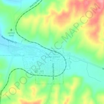
Name: St. John topographic map, elevation, terrain.
Location: St. John, Whitman County, Washington, 99171, United States (47.08445 -117.61138 47.10097 -117.57462)
Average elevation: 2,077 ft
Minimum elevation: 1,936 ft
Maximum elevation: 2,320 ft
Whitman County trails, hiking, mountain biking, running and outdoor activities
Other topographic maps
Click on a map to view its topography, its elevation and its terrain.
Oaksdale City Park
United States > Washington > Whitman County > Oakesdale
Average elevation: 2,523 ft
Colfax
United States > Washington > Whitman County > Colfax > Colfax
Colfax is located in southeastern Washington at 46°53′3″N 117°21′49″W / 46.88417°N 117.36361°W / 46.88417; -117.36361 (46.884033, -117.363668), at an elevation of 1,962 feet (598 m). The nearest cities are Spokane, Pullman, Moscow, and Lewiston/Clarkston. The area is geologically…
Average elevation: 2,260 ft
LaCrosse
United States > Washington > Whitman County > La Crosse > LaCrosse
Average elevation: 1,545 ft