Geolocate

Corbin topographic map

Click on the map to display elevation.

About this map

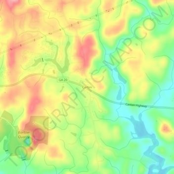
Name: Corbin topographic map, elevation, terrain.

Location: Corbin, Bartow County, Georgia, 30184, United States (34.20010 -84.71549 34.24010 -84.67549)

Average elevation: 1,010 ft

Minimum elevation: 830 ft

Maximum elevation: 1,194 ft

Other topographic maps

Click on a map to view its topography, its elevation and its terrain.

Cartersville

United States > Georgia > Bartow County

Average elevation: 853 ft

Euharlee

United States > Georgia > Bartow County

Average elevation: 705 ft

Emerson

United States > Georgia > Bartow County

Average elevation: 833 ft

Kingston

United States > Georgia > Bartow County

Average elevation: 732 ft

Adairsville

United States > Georgia > Bartow County

Average elevation: 833 ft

Emerson

United States > Georgia > Bartow County

Average elevation: 833 ft

Euharlee

United States > Georgia > Bartow County

Average elevation: 705 ft

Kingston

United States > Georgia > Bartow County

Average elevation: 732 ft

Cartersville

United States > Georgia > Bartow County

Average elevation: 853 ft

White

United States > Georgia > Bartow County > White

Average elevation: 889 ft

Gear up for your next adventure:

📚USA Hiking Guide Books - Top trail guides and map books
🧺Microfiber Travel Towels - Compact and fast-drying towels for trail use
🩳Quick‑Dry Hiking Shorts - Comfortable and quick‑dry shorts for summer hiking
☀️Outdoor Sunscreen - High protection sunscreen for outdoor activities
🦟Ultrasonic Repellers - Create a bug-free zone at your camp or rest stop

As an Amazon Associate, this site earns from qualifying purchases at no extra cost to you.