Geolocate

Beaver topographic map

Click on the map to display elevation.

About this map

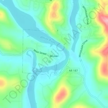
Name: Beaver topographic map, elevation, terrain.

Location: Beaver, Carroll County, Arkansas, 72613, United States (36.46897 -93.77903 36.48134 -93.76429)

Average elevation: 1,030 ft

Minimum elevation: 902 ft

Maximum elevation: 1,391 ft

Carroll County trails, hiking, mountain biking, running and outdoor activities

Other topographic maps

Click on a map to view its topography, its elevation and its terrain.

Holiday Island

United States > Arkansas > Carroll County

Average elevation: 1,188 ft

Delmar

United States > Arkansas > Carroll County

Average elevation: 1,755 ft

Inspiration Point

United States > Arkansas > Carroll County

Average elevation: 1,250 ft

Osage

United States > Arkansas > Carroll County

Average elevation: 1,526 ft

Eureka Springs

United States > Arkansas > Carroll County > Eureka Springs

It is a tourist destination for its unique character as a Victorian resort village. The city has steep winding streets filled with Victorian-style cottages and manors. The historic commercial downtown of the city has an extensive streetscape of well-preserved Victorian buildings. The buildings are primarily…

Average elevation: 1,368 ft

Gear up for your next adventure:

🌲Outdoor Survival Books - Best books on survival skills
🎒Gear Packing Cubes - Organize your backpack efficiently
🧼Biodegradable Camping Soap - Eco‑friendly soap for outdoor hygiene
📷Action Camera - Capture your outdoor adventures in HD
🪓Survival Multi‑Tool - Versatile tool for camp and trail tasks

As an Amazon Associate, this site earns from qualifying purchases at no extra cost to you.