Geolocate

Carlsborg topographic map

Click on the map to display elevation.

About this map

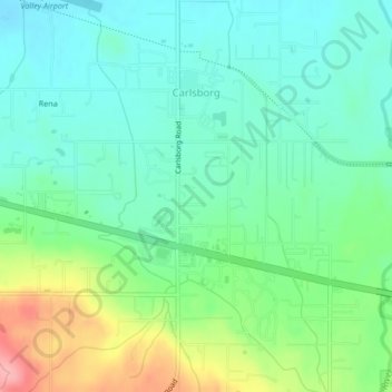
Name: Carlsborg topographic map, elevation, terrain.

Location: Carlsborg, Clallam County, Washington, 98324, United States (48.06918 -123.18282 48.09705 -123.15663)

Average elevation: 240 ft

Minimum elevation: 128 ft

Maximum elevation: 502 ft

Clallam County trails, hiking, mountain biking, running and outdoor activities

Other topographic maps

Click on a map to view its topography, its elevation and its terrain.

Ramapo

United States > Washington > Clallam County

Average elevation: 420 ft

La Push

United States > Washington > Clallam County

Average elevation: 56 ft

Beaver

United States > Washington > Clallam County

Average elevation: 604 ft

Elwha

United States > Washington > Clallam County

Average elevation: 912 ft

Maple Grove

United States > Washington > Clallam County

Average elevation: 1,263 ft

Elwha

United States > Washington > Clallam County

Average elevation: 912 ft

Agnew

United States > Washington > Clallam County

Average elevation: 177 ft

Hoko River

United States > Washington > Clallam County

Average elevation: 679 ft

Clallam Bay

United States > Washington > Clallam County

Average elevation: 128 ft

Lake Crescent

United States > Washington > Clallam County

Average elevation: 1,850 ft

Gear up for your next adventure:

💧Water Purification System - Clean water on the trail with reliable purifiers
🪶LED Camping Lantern - Bright lantern for camp lighting
🌲Outdoor Survival Books - Best books on survival skills
📦Gear Storage Bags - Organize and protect outdoor equipment
🕶️GPS Smartphone Mount - Secure mount for phone navigation

As an Amazon Associate, this site earns from qualifying purchases at no extra cost to you.