
Callery topographic map
Click on the map to display elevation.
About this map
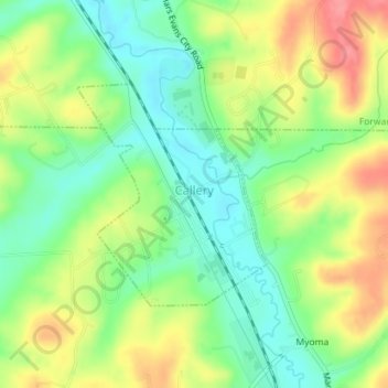
Name: Callery topographic map, elevation, terrain.
Location: Callery, Butler County, Pennsylvania, 16024, United States (40.73255 -80.04725 40.74800 -80.02969)
Average elevation: 1,053 ft
Minimum elevation: 938 ft
Maximum elevation: 1,204 ft
Butler County trails, hiking, mountain biking, running and outdoor activities
Other topographic maps
Click on a map to view its topography, its elevation and its terrain.
Buhls Station
United States > Pennsylvania > Butler County > Buhls Station
Average elevation: 1,102 ft
Glen Eden
United States > Pennsylvania > Butler County > Cranberry Township
Average elevation: 1,148 ft
Petersville
United States > Pennsylvania > Butler County > Connoquenessing > Petersville
Average elevation: 1,207 ft