
Make a donation
Gear up for your next adventure:
As an Amazon Associate, this site earns from qualifying purchases at no extra cost to you.
Reynella East topographic map
Click on the map to display elevation.
Make a donation
Gear up for your next adventure:
As an Amazon Associate, this site earns from qualifying purchases at no extra cost to you.
About this map
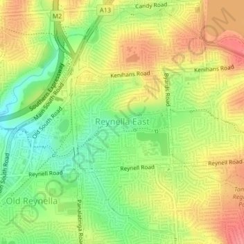
Name: Reynella East topographic map, elevation, terrain.
Average elevation: 413 ft
Minimum elevation: 285 ft
Maximum elevation: 535 ft
Make a donation
Gear up for your next adventure:
As an Amazon Associate, this site earns from qualifying purchases at no extra cost to you.
Other topographic maps
Click on a map to view its topography, its elevation and its terrain.
Happy Valley Reservoir
Australia > South Australia > City of Onkaparinga > Adelaide
Average elevation: 538 ft
Happy Valley Reservior
Australia > South Australia > City of Onkaparinga > Adelaide
Average elevation: 568 ft
Port Noarlunga Reef Sanctuary Zone
Australia > South Australia > City of Onkaparinga > Adelaide
Average elevation: 3 ft
Adelaide (Sellicks Hill) Weather Radar
Australia > South Australia > City of Onkaparinga > Adelaide
Average elevation: 955 ft
Make a donation
Gear up for your next adventure:
As an Amazon Associate, this site earns from qualifying purchases at no extra cost to you.