Geolocate

Woodcreek topographic map

Interactive map

Click on the map to display elevation.

About this map

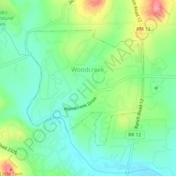
Name: Woodcreek topographic map, elevation, terrain.

Location: Woodcreek, Hays County, Texas, United States (30.01652 -98.12214 30.03430 -98.10131)

Average elevation: 991 ft

Minimum elevation: 883 ft

Maximum elevation: 1,201 ft

Hays County trails, hiking, mountain biking, running and outdoor activities

Other topographic maps

Click on a map to view its topography, its elevation and its terrain.

Sewell Park

United States > Texas > Hays County > San Marcos

Average elevation: 630 ft

Goforth

United States > Texas > Hays County

Average elevation: 627 ft

Kyle

United States > Texas > Hays County

Average elevation: 709 ft

Pioneer Town

United States > Texas > Hays County > Wimberley

Average elevation: 932 ft

Mount Gainor

United States > Texas > Hays County

Average elevation: 1,224 ft

Driftwood

United States > Texas > Hays County

Average elevation: 1,047 ft

Wimberley

United States > Texas > Hays County > Wimberley > Wimberley

Average elevation: 988 ft

Henly

United States > Texas > Hays County

Average elevation: 1,329 ft

Kyle

United States > Texas > Hays County > Kyle

Average elevation: 709 ft

Mount Sharp

United States > Texas > Hays County

Average elevation: 1,407 ft