Geolocate

Devils Gate topographic map

Click on the map to display elevation.

About this map

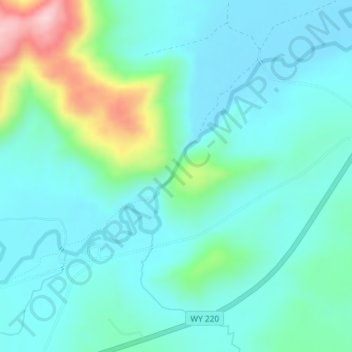
Name: Devils Gate topographic map, elevation, terrain.

Location: Devils Gate, Natrona County, Wyoming, United States (42.44822 -107.21002 42.44832 -107.20992)

Average elevation: 6,093 ft

Minimum elevation: 5,919 ft

Maximum elevation: 6,765 ft

Other topographic maps

Click on a map to view its topography, its elevation and its terrain.

Midwest

United States > Wyoming > Natrona County

The town of Midwest, located in Natrona County, Wyoming, sits in a relatively flat, semi-arid landscape characterized by the rolling hills and gentle slopes typical of the Great Plains region. The area's topography is largely defined by expansive grasslands and isolated buttes. Midwest is positioned near…

Average elevation: 4,862 ft

Casper

United States > Wyoming > Natrona County

Average elevation: 5,659 ft

Alcova

United States > Wyoming > Natrona County > Alcova

Average elevation: 5,463 ft

Casper

United States > Wyoming > Natrona County

Average elevation: 5,659 ft

Casper

United States > Wyoming > Natrona County

Average elevation: 5,659 ft

Bar Nunn

United States > Wyoming > Natrona County

Average elevation: 5,312 ft

Midwest

United States > Wyoming > Natrona County

Average elevation: 4,862 ft

Casper

United States > Wyoming > Natrona County

Average elevation: 5,364 ft

Gear up for your next adventure:

🌧️Backpack Rain Cover - Keep gear dry in wet weather
🧤Tactile Hiking Gloves - Keep hands warm while operating GPS and smartphone screens
🎒Trail Energy Bars - High‑calorie bars for hiking energy
📖Nature Tracking Books - Learn to track wildlife and terrain
🧢Outdoor Hiking Hat - Sun protection hat for outdoor explorers

As an Amazon Associate, this site earns from qualifying purchases at no extra cost to you.