
Midwest topographic map
Click on the map to display elevation.
Midwest
The town of Midwest, located in Natrona County, Wyoming, sits in a relatively flat, semi-arid landscape characterized by the rolling hills and gentle slopes typical of the Great Plains region. The area's topography is largely defined by expansive grasslands and isolated buttes. Midwest is positioned near several reservoirs, and its surroundings include gentle ridges and valley areas. These features indicate the gradual transitions of the land from upland plateaus to lower terrain where water bodies like the Castle Creek are found. The landscape, while not mountainous, shows a subtle variability that offers views of both open expanses and slightly rugged terrain, shaped by erosion and seasonal water flow.
About this map
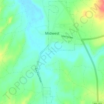
Name: Midwest topographic map, elevation, terrain.
Location: Midwest, Natrona County, Wyoming, United States (43.39323 -106.28563 43.41977 -106.26896)
Average elevation: 4,862 ft
Minimum elevation: 4,793 ft
Maximum elevation: 5,020 ft
Natrona County trails, hiking, mountain biking, running and outdoor activities
Other topographic maps
Click on a map to view its topography, its elevation and its terrain.
Casper Mountain
United States > Wyoming > Natrona County
Casper Mountain, an anticline, is located at the north end of the Laramie Mountains overlooking Casper, Wyoming along the North Platte River. At a top elevation of 8,130 feet (2,478 m), the geological feature rises approximately 3,000 feet (914 m) above Casper.
Average elevation: 7,595 ft