Geolocate

Blaichach topographic map

Click on the map to display elevation.

About this map

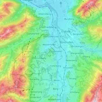
Name: Blaichach topographic map, elevation, terrain.

Location: Blaichach, Landkreis Oberallgäu, Bavaria, 87544, Germany (47.45411 10.10468 47.55401 10.26695)

Average elevation: 3,291 ft

Minimum elevation: 2,339 ft

Maximum elevation: 5,951 ft

Other topographic maps

Click on a map to view its topography, its elevation and its terrain.

Bischlags

Germany > Bavaria > Landkreis Oberallgäu > Seebach

Average elevation: 2,428 ft

Ellensberg

Germany > Bavaria > Landkreis Oberallgäu > Lauben

Average elevation: 2,208 ft

Gear up for your next adventure:

🪶Paracord Bracelet - Survival bracelet with built‑in tools
🪵Folding Camp Saw - Compact saw for wood and campsite work
🦟Ultrasonic Repellers - Create a bug-free zone at your camp or rest stop
🔥Fast-Boil Camping Stoves - Efficient cooking systems for quick trail meals
📷Action Camera - Capture your outdoor adventures in HD

As an Amazon Associate, this site earns from qualifying purchases at no extra cost to you.