Geolocate

Monsefú topographic map

Click on the map to display elevation.

About this map

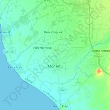
Name: Monsefú topographic map, elevation, terrain.

Location: Monsefú, Province of Chiclayo, Lambayeque, Peru (-6.90843 -79.90775 -6.82002 -79.77043)

Average elevation: 43 ft

Minimum elevation: -16 ft

Maximum elevation: 256 ft

Other topographic maps

Click on a map to view its topography, its elevation and its terrain.

Los Jagueyes de Mayascón

Peru > Lambayeque > Pítipo

Average elevation: 1,821 ft

Mayascón

Peru > Lambayeque

Average elevation: 1,319 ft

C

Peru > Lambayeque > Chiclayo

Average elevation: 79 ft

Mocupe

Peru > Lambayeque

Average elevation: 115 ft

Morrope

Peru > Lambayeque > Mórrope

Average elevation: 62 ft

Chiclayo

Peru > Lambayeque > Chiclayo

Average elevation: 128 ft

Puerto Etén

Peru > Lambayeque > Etén Puerto > Puerto Etén

Average elevation: 36 ft

Gear up for your next adventure:

🧭Map Reading Tools - Tools and kits for map navigation
🗺️Topographic Maps - Detailed topo maps for hiking, exploring and outdoor navigation
🎒Hydration Pack - Hands‑free water reservoir for long hikes
🔥Plasma Lighters - Windproof lighters that work in any weather condition
🔭Stargazing Telescopes - Perfect for camping in low-light pollution areas shown on maps

As an Amazon Associate, this site earns from qualifying purchases at no extra cost to you.