Geolocate

Requena topographic map

Click on the map to display elevation.

About this map

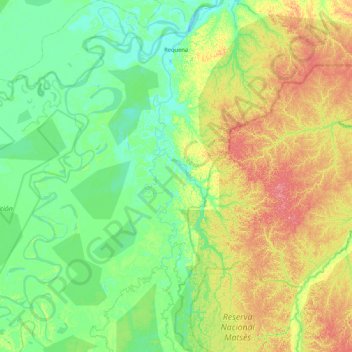
Name: Requena topographic map, elevation, terrain.

Location: Requena, Province of Requena, Loreto, Peru (-5.78378 -74.17742 -4.94651 -73.60119)

Average elevation: 381 ft

Minimum elevation: 292 ft

Maximum elevation: 604 ft

Other topographic maps

Click on a map to view its topography, its elevation and its terrain.

Isla Iquitos

Peru > Loreto > Belén

Average elevation: 282 ft

Isla Iquitos

Peru > Loreto > Belén

Average elevation: 282 ft

San Alejandro

Peru > Loreto > Mazán

Average elevation: 279 ft

Centro America

Peru > Loreto > Balas Puerto

Average elevation: 509 ft

Pucalpillo

Peru > Loreto > Balas Puerto

Average elevation: 627 ft

Güeppi

Peru > Loreto > Teniente Manuel Clavero

Average elevation: 646 ft

Centro America

Peru > Loreto > Balas Puerto

Average elevation: 509 ft

San Rogue

Peru > Loreto

Average elevation: 341 ft

Antioquia

Peru > Loreto

Average elevation: 673 ft

Francisco de Orellana

Peru > Loreto > Las Amazonas

Average elevation: 266 ft

Naciente del Amazonas

Peru > Loreto > Nauta

Average elevation: 325 ft

Santa Fe

Peru > Loreto > Emilio San Martín

Average elevation: 338 ft

Cuchara

Peru > Loreto > Trompeteros

Average elevation: 413 ft

Manchuria

Peru > Loreto > Manchuria

Average elevation: 410 ft

Puma

Peru > Loreto > Contamana

Average elevation: 413 ft

Cartagena

Peru > Loreto > Yurimaguas > Cartagena

Average elevation: 476 ft

Quebrada SanJuan

Peru > Loreto > Trompeteros

Average elevation: 479 ft

Gear up for your next adventure:

🌎3D Topographic Globes - Raised relief globes for a tactile understanding of geography
📚USA Hiking Guide Books - Top trail guides and map books
🪶Camping Sleeping Pad - Comfortable sleeping pad for backpacking
🪑Portable Camp Table - Compact table for campsite meals
🥤Water Filter Bottle - All‑in‑one filter bottle for safe hydration

As an Amazon Associate, this site earns from qualifying purchases at no extra cost to you.