Geolocate

Hamata topographic map

Click on the map to display elevation.

About this map

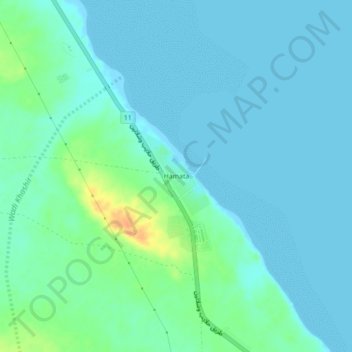
Name: Hamata topographic map, elevation, terrain.

Location: Hamata, Red Sea, Egypt (24.26562 35.35671 24.30562 35.39671)

Average elevation: 26 ft

Minimum elevation: -3 ft

Maximum elevation: 118 ft

Other topographic maps

Click on a map to view its topography, its elevation and its terrain.

Gulf of Suez

Egypt > Red Sea

Average elevation: 1,578 ft

Al Hadaba

Egypt > Red Sea

Average elevation: 135 ft

Al Hadaba

Egypt > Red Sea

Average elevation: 135 ft

Industrial Area

Egypt > Red Sea

Average elevation: 125 ft

Wadi Gemal

Egypt > Red Sea

Average elevation: 1,227 ft

Safaja

Egypt > Red Sea

Average elevation: 3 ft

Gulf of Suez

Egypt > Red Sea

Average elevation: 1,578 ft

Marsa Alam City

Egypt > Red Sea

Average elevation: 62 ft

Gamsha

Egypt > Red Sea

Average elevation: 154 ft

Geziret Tubya

Egypt > Red Sea > Safaja

Average elevation: 0 ft

Al Qusair City

Egypt > Red Sea

Average elevation: 154 ft

Industrial Area

Egypt > Red Sea

Average elevation: 125 ft

Fresh water pool, cold

Egypt > Red Sea > Al Qusair City

Average elevation: 26 ft

Al Ahia'

Egypt > Red Sea

Average elevation: 52 ft

Gear up for your next adventure:

🏕️Tent Footprint - Protect your tent base from wear
🪶Survival Guide Book - Expert advice for emergency preparedness
🧯Emergency Survival Kit - All‑in‑one survival essentials for the backcountry
🏔️Mountain Trail Maps - High‑detail maps for popular peaks
📻Weather Alert Radios - Stay informed of storm risks while off-the-grid

As an Amazon Associate, this site earns from qualifying purchases at no extra cost to you.