
Make a donation
Gear up for your next adventure:
As an Amazon Associate, this site earns from qualifying purchases at no extra cost to you.
Khan Chamkar Mon topographic map
Click on the map to display elevation.
Make a donation
Gear up for your next adventure:
As an Amazon Associate, this site earns from qualifying purchases at no extra cost to you.
About this map
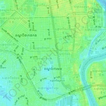
Name: Khan Chamkar Mon topographic map, elevation, terrain.
Location: Khan Chamkar Mon, Phnom Penh, Cambodia (11.52697 104.90903 11.55917 104.94658)
Average elevation: 39 ft
Minimum elevation: 13 ft
Maximum elevation: 66 ft
Make a donation
Gear up for your next adventure:
As an Amazon Associate, this site earns from qualifying purchases at no extra cost to you.
Other topographic maps
Click on a map to view its topography, its elevation and its terrain.
Make a donation
Gear up for your next adventure:
As an Amazon Associate, this site earns from qualifying purchases at no extra cost to you.
Phum Thnaot Chrum
Cambodia > Phnom Penh > Khan Mean Chey > Sangkat Boeng Tumpun 1
Average elevation: 33 ft
Phum Damnak Thom
Cambodia > Phnom Penh > Khan Mean Chey > Sangkat Stueng Mean Chey 2
Average elevation: 36 ft
Make a donation
Gear up for your next adventure:
As an Amazon Associate, this site earns from qualifying purchases at no extra cost to you.
Phum Prey Doun Ok
Cambodia > Phnom Penh > Khan Pou Senchey > Sangkat Trapeang Krosang
Average elevation: 52 ft
Make a donation
Gear up for your next adventure:
As an Amazon Associate, this site earns from qualifying purchases at no extra cost to you.
Phum Thnal Bambaek
Cambodia > Phnom Penh > Khan Pou Senchey > Prey Pring Khang Tboung 1
Average elevation: 46 ft
Phum Pothi Mongkol
Cambodia > Phnom Penh > Khan Prek Pnov > Sangkat Prek Pnov
Average elevation: 30 ft
Phum Kien Khleang
Cambodia > Phnom Penh > Khan Chroy Changvar > Sangkat Chroy Changvar
Average elevation: 30 ft
Make a donation
Gear up for your next adventure:
As an Amazon Associate, this site earns from qualifying purchases at no extra cost to you.
Sangkat Phsar Thmey Ti Muoy
Cambodia > Phnom Penh > Khan Daun Penh > Sangkat Phsar Thmey Ti Muoy
Average elevation: 43 ft
Sangkat Phsar Kandal Ti Muoy
Cambodia > Phnom Penh > Khan Daun Penh > Sangkat Phsar Kandal Ti Muoy
Average elevation: 39 ft
Make a donation
Gear up for your next adventure:
As an Amazon Associate, this site earns from qualifying purchases at no extra cost to you.
Boeung Kak Community
Cambodia > Phnom Penh > Khan Daun Penh > Boeung Kak Community
Average elevation: 39 ft
Make a donation
Gear up for your next adventure:
As an Amazon Associate, this site earns from qualifying purchases at no extra cost to you.