
Make a donation
Gear up for your next adventure:
As an Amazon Associate, this site earns from qualifying purchases at no extra cost to you.
Vestea topographic map
Click on the map to display elevation.
Make a donation
Gear up for your next adventure:
As an Amazon Associate, this site earns from qualifying purchases at no extra cost to you.
About this map
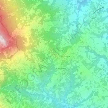
Name: Vestea topographic map, elevation, terrain.
Location: Vestea, Civitella Casanova, Pescara, Abruzzo, Italy (42.36936 13.86514 42.40936 13.90514)
Average elevation: 1,772 ft
Minimum elevation: 928 ft
Maximum elevation: 3,730 ft
Make a donation
Gear up for your next adventure:
As an Amazon Associate, this site earns from qualifying purchases at no extra cost to you.
Other topographic maps
Click on a map to view its topography, its elevation and its terrain.
Make a donation
Gear up for your next adventure:
As an Amazon Associate, this site earns from qualifying purchases at no extra cost to you.
Make a donation
Gear up for your next adventure:
As an Amazon Associate, this site earns from qualifying purchases at no extra cost to you.
Civitella Casanova
The current village, growing, grew in the foothills of the majestic Gran Sasso chain at the foot of Mount Cimoni—elevation 1,404 metres (4,606 ft), and Mt Colle Madonna, elevation 1,350 metres (4,430 ft)—from a village, relatively old and homely in dimensions, called Terravecchia. Built of stone and brick,…
Average elevation: 1,772 ft
Make a donation
Gear up for your next adventure:
As an Amazon Associate, this site earns from qualifying purchases at no extra cost to you.
Make a donation
Gear up for your next adventure:
As an Amazon Associate, this site earns from qualifying purchases at no extra cost to you.
Make a donation
Gear up for your next adventure:
As an Amazon Associate, this site earns from qualifying purchases at no extra cost to you.
San Valentino in Abruzzo Citeriore
Italy > Abruzzo > Pescara > San Valentino in Abruzzo Citeriore
Average elevation: 1,083 ft