
Make a donation
Gear up for your next adventure:
As an Amazon Associate, this site earns from qualifying purchases at no extra cost to you.
Bolognano topographic map
Click on the map to display elevation.
Make a donation
Gear up for your next adventure:
As an Amazon Associate, this site earns from qualifying purchases at no extra cost to you.
About this map
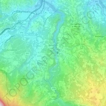
Name: Bolognano topographic map, elevation, terrain.
Location: Bolognano, Pescara, Abruzzo, Italy (42.16950 13.93069 42.25403 13.97241)
Average elevation: 1,335 ft
Minimum elevation: 381 ft
Maximum elevation: 4,587 ft
Make a donation
Gear up for your next adventure:
As an Amazon Associate, this site earns from qualifying purchases at no extra cost to you.
Other topographic maps
Click on a map to view its topography, its elevation and its terrain.
Make a donation
Gear up for your next adventure:
As an Amazon Associate, this site earns from qualifying purchases at no extra cost to you.
Città Sant'Angelo
Italy > Abruzzo > Pescara > Città Sant'Angelo > Città Sant'Angelo
Average elevation: 404 ft
Make a donation
Gear up for your next adventure:
As an Amazon Associate, this site earns from qualifying purchases at no extra cost to you.