
Make a donation
Gear up for your next adventure:
As an Amazon Associate, this site earns from qualifying purchases at no extra cost to you.
Civitella Casanova topographic map
Click on the map to display elevation.
Make a donation
Gear up for your next adventure:
As an Amazon Associate, this site earns from qualifying purchases at no extra cost to you.
Civitella Casanova
The current village, growing, grew in the foothills of the majestic Gran Sasso chain at the foot of Mount Cimoni—elevation 1,404 metres (4,606 ft), and Mt Colle Madonna, elevation 1,350 metres (4,430 ft)—from a village, relatively old and homely in dimensions, called Terravecchia. Built of stone and brick, this small village is situated on a rocky outcrop and is the most remote and evocative of the historic center in Roman times was called Cutina or Cingilia. On it stood the ponderous Castrum Rossi di Civitella, which was destroyed by a disastrous earthquake in 1456, and the Church of San Marco which today remains only a stone, on which there was built a new house, but left intentionally exposed by the owners. Subsequently, many buildings were swallowed by a landslide which brought with it a large part of the area, reducing the current strip of land we see today. Conseguenzialmente these events there was a need for the development of a new country: its subsequent expansion, in fact, led him to develop the hill to the west, up the slopes of the mountain. Its elongated shape today is crossed by a long straight axis, which some believe is one of the longer courses available throughout the province, bordered by rows of houses almost uninterrupted. Terravecchia is now very attractive, because of its walls stone and brick, the winding streets and steep stairways, and its architecture is still of considerable interest. The two nuclei are gathered today, and there are buildings of superior construction quality. The elevation of the town is known to be 400 metres (1,300 ft) above sea level, the point at which it is built the municipal building: few people know, however, that the highest point of the municipality measuring 1,581 metres (5,187 ft), height of the mountain Top of Cioccola observable by the fraction Baffo and Centelle, part of the town of Civitella. It sopraeleva behind the mountains above Cimoni and Colle Madonna forming the plain with lace, or a barrier of rock composed of limestone pinnacles, which in fact is the door of the flat Voltigno. Civitella in higher altitudes has a large area of this plateau, which includes the three mountains of the town, because in these places has the typical characteristic landscape mountain, where there are large beech and oak and fir trees, we can find the area of wildlife chamois 'Abruzzo, where there are also buzzards, peregrine falcons, deer, the Apennine wolf, wild cat, and once the bear. Excellent destination for mountain lovers and for those who love to be surrounded by greenery, close to the country from which you can see, looking towards the mountains, this pristine nature. The plateau of Voltigno is about 1,300 metres (4,300 ft) above sea level and is often visited by tourists and people who love the mountains, but there is also practiced sports, including cycling and cross-country skiing in winter. Just here, on the mountain Colle Madonna, originates the source of Rivo Clear that, by the eponymous waterfall frozen in winter (great for climbing mountaineering, gives rise to stream Schiavone, fed by the waters of the Festina river, then the river confluence Nora. There is also a small karst lake, fed mainly by snowfall winter, Lake Background, the only one that dries up in summer in spite of the other small ponds that have the same origin. According to popular belief, the lake has no bottom and flows directly into the Adriatic Sea. Civitella Casanova also has a large area of natural interest outside the city center, in the district Furnace, you can visit the Zoo Park, the Cliff, while to the north of the Hill truncheons, in Festina location at 790 metres (2,590 ft) above sea level there is a spring of sulphurous water [15], usually not easily recepibile and conducive to many cures for acne, arthritis, asthma-like bronchitis, catarrhal bronchitis, eczema seborrico, lymphatism eretistico, acute articular rheumatism, rinofaringo - chronic laryngitis, deafness . [16] In addition, however, also become a tourist spot of the high mountains of the town and turned into a pretty fountain, there are mountains in at least three other main sources for drinking water.
Make a donation
Gear up for your next adventure:
As an Amazon Associate, this site earns from qualifying purchases at no extra cost to you.
About this map
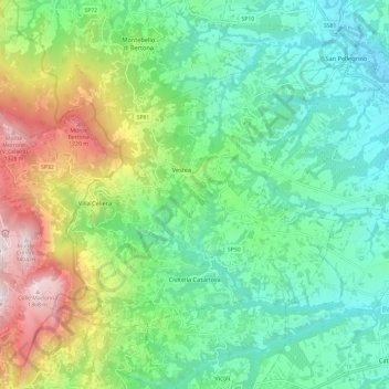
Name: Civitella Casanova topographic map, elevation, terrain.
Location: Civitella Casanova, Pescara, Abruzzo, Italy (42.35367 13.81373 42.41376 13.93272)
Average elevation: 1,772 ft
Minimum elevation: 545 ft
Maximum elevation: 4,616 ft
Make a donation
Gear up for your next adventure:
As an Amazon Associate, this site earns from qualifying purchases at no extra cost to you.
Other topographic maps
Click on a map to view its topography, its elevation and its terrain.
Make a donation
Gear up for your next adventure:
As an Amazon Associate, this site earns from qualifying purchases at no extra cost to you.
Città Sant'Angelo
Italy > Abruzzo > Pescara > Città Sant'Angelo > Città Sant'Angelo
Average elevation: 404 ft
Make a donation
Gear up for your next adventure:
As an Amazon Associate, this site earns from qualifying purchases at no extra cost to you.