Geolocate

Lordstown topographic map

Click on the map to display elevation.

About this map

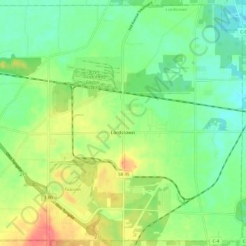
Name: Lordstown topographic map, elevation, terrain.

Location: Lordstown, Trumbull County, Ohio, United States (41.13423 -80.90620 41.20326 -80.81089)

Average elevation: 938 ft

Minimum elevation: 856 ft

Maximum elevation: 1,076 ft

Trumbull County trails, hiking, mountain biking, running and outdoor activities

Other topographic maps

Click on a map to view its topography, its elevation and its terrain.

Hardscrabble

United States > Ohio > Trumbull County > Warren

Average elevation: 906 ft

Greene

United States > Ohio > Trumbull County > Greene

Average elevation: 945 ft

Tyrrell

United States > Ohio > Trumbull County > Tyrrell

Average elevation: 1,119 ft

Gear up for your next adventure:

🧴Hand Sanitizer - Keep hands clean while hiking
🗺️NatGeo Topo Maps - High-quality waterproof printed topographic maps of US Parks
🧯Portable Fire Pit - Compact fire pit for camping spots
🏔️Mountain Trail Maps - High‑detail maps for popular peaks
🔥Camping Stove - Portable stove for camping and backcountry cooking

As an Amazon Associate, this site earns from qualifying purchases at no extra cost to you.