Geolocate

North Raker topographic map

Click on the map to display elevation.

About this map

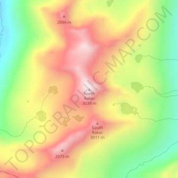
Name: North Raker topographic map, elevation, terrain.

Location: North Raker, Boise County, Idaho, United States (43.99275 -115.10378 43.99285 -115.10368)

Average elevation: 8,698 ft

Minimum elevation: 7,513 ft

Maximum elevation: 9,803 ft

Boise County trails, hiking, mountain biking, running and outdoor activities

Other topographic maps

Click on a map to view its topography, its elevation and its terrain.

Crouch

United States > Idaho > Boise County

Average elevation: 3,159 ft

Placerville

United States > Idaho > Boise County

Average elevation: 4,406 ft

Gear up for your next adventure:

🥇GPS Hiking Watch - Multi‑sport GPS watch with navigation and trail tracking
📷Action Cameras - Rugged cameras to document your journeys across rugged terrain
🥄Camping Utensil Set - Lightweight utensils for outdoor meals
🚑Emergency Bivvies - Heat-reflective sleeping bags for survival situations
📖Nature Tracking Books - Learn to track wildlife and terrain

As an Amazon Associate, this site earns from qualifying purchases at no extra cost to you.