
Middlegate topographic map
Click on the map to display elevation.
About this map
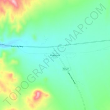
Name: Middlegate topographic map, elevation, terrain.
Location: Middlegate, Churchill County, Nevada, United States (39.26721 -118.04720 39.30721 -118.00720)
Average elevation: 4,734 ft
Minimum elevation: 4,524 ft
Maximum elevation: 5,253 ft
Churchill County trails, hiking, mountain biking, running and outdoor activities
Other topographic maps
Click on a map to view its topography, its elevation and its terrain.
Dixie Valley - Fairview Peak 7.1 Earthquake 1954 Fault Line
United States > Nevada > Churchill County
Average elevation: 5,961 ft