Geolocate

Sotik topographic map

Click on the map to display elevation.

About this map

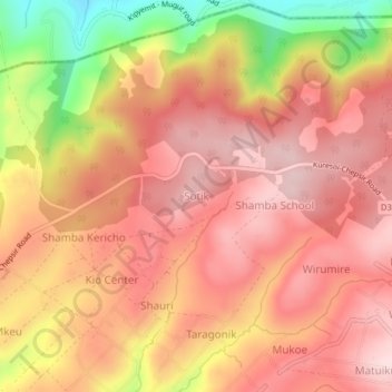
Name: Sotik topographic map, elevation, terrain.

Location: Sotik, Nakuru, Kenya (-0.30952 35.48086 -0.26952 35.52086)

Average elevation: 8,130 ft

Minimum elevation: 7,431 ft

Maximum elevation: 8,478 ft

Other topographic maps

Click on a map to view its topography, its elevation and its terrain.

Njoro

Kenya > Nakuru

Average elevation: 7,917 ft

Lake Naivasha

Kenya > Nakuru > Lake Naivasha Simba Lodge

Average elevation: 6,220 ft

Olkaria ward

Kenya > Nakuru > Naivasha

Average elevation: 6,388 ft

Gear up for your next adventure:

🏥Hiking First Aid Kits - Comprehensive medical kits for remote trail injuries
🗺️NatGeo Topo Maps - High-quality waterproof printed topographic maps of US Parks
🎒Gear Packing Cubes - Organize your backpack efficiently
🛡️Bear Spray Outdoor - Protection in bear country hikes
☀️Outdoor Sunscreen - High protection sunscreen for outdoor activities

As an Amazon Associate, this site earns from qualifying purchases at no extra cost to you.