Geolocate

Lake topographic map

Click on the map to display elevation.

About this map

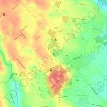
Name: Lake topographic map, elevation, terrain.

Location: Lake, Karen, Nairobi, Nairobi County, Kenya (-1.32073 36.70297 -1.32033 36.70328)

Average elevation: 6,135 ft

Minimum elevation: 6,014 ft

Maximum elevation: 6,220 ft

Other topographic maps

Click on a map to view its topography, its elevation and its terrain.

Roysambu ward

Kenya > Nairobi County > Nairobi

Average elevation: 5,361 ft

Ruaraka

Kenya > Nairobi County > Nairobi

Average elevation: 5,302 ft

Kagondo

Kenya > Nairobi County > Nairobi

Average elevation: 6,224 ft

Gear up for your next adventure:

🪶Wildlife Field Guides - Learn animal tracking and species ID
🗺️NatGeo Topo Maps - High-quality waterproof printed topographic maps of US Parks
🔭Telescopic Hiking Pole - Adjustable pole for hiking stability
🛡️Bear Spray Outdoor - Protection in bear country hikes
🗻Climbing Gear Basics - Essential gear for beginner climbers

As an Amazon Associate, this site earns from qualifying purchases at no extra cost to you.